Chong-Kemin is the green valley most travelers blow straight past on the drive between Bishkek and Issyk-Kul, and that’s exactly its appeal. It’s a national park roughly two to three hours east of Bishkek where you can trek or ride horses for two to four days through summer pastures, up a long river valley, and over a pass toward the lake. A quieter, less-trodden alternative to the country’s famous routes. The valley runs east from the Bishkek-Issyk-Kul corridor deep into the Kungey Ala-Too, and in summer its floor and side gullies fill with nomad herders and their livestock.
The draw here isn’t a single trophy lake or a famous pass — it’s the texture of everyday mountain life at close range, on trails you’ll often have to yourself. That makes Chong-Kemin a good pick for travelers who’ve read about the crowds on the marquee treks and want something with more space and less traffic. It takes a little more effort to arrange, which is precisely why fewer people are on it.
What the Valley Is Like
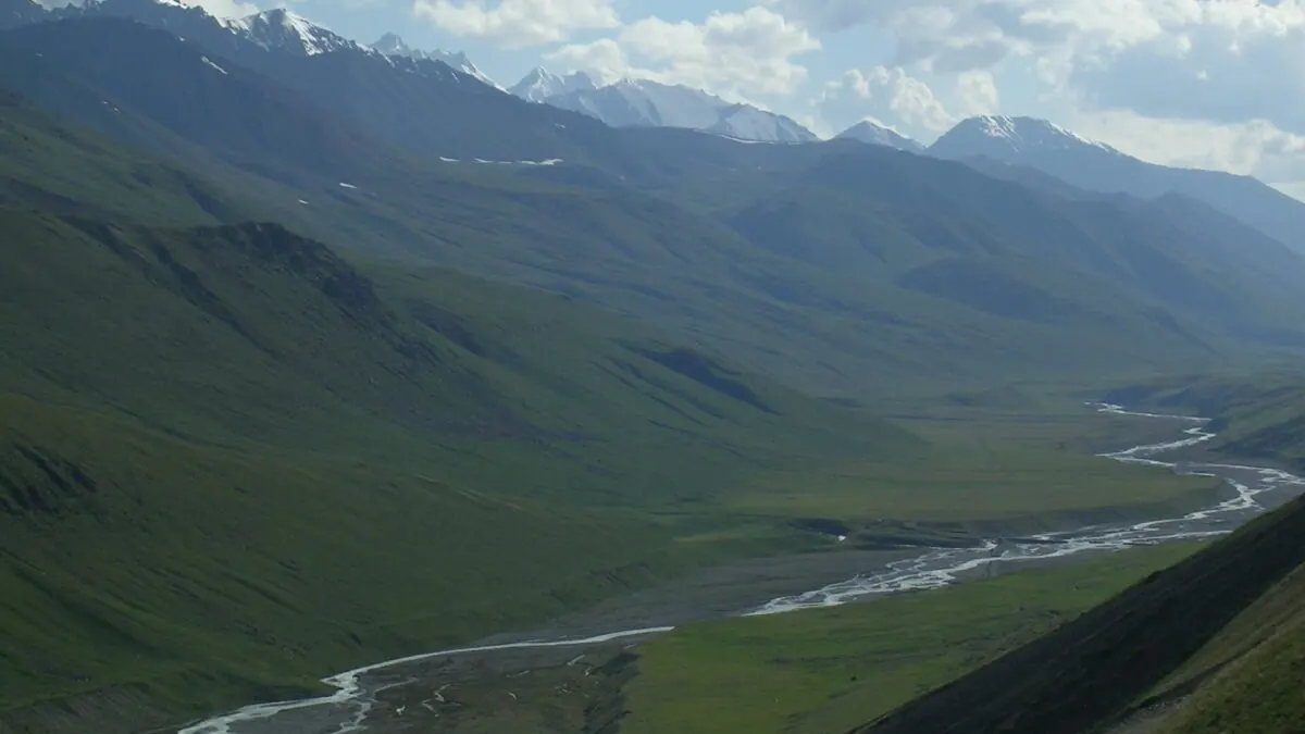
Chong-Kemin is a long, broad glacial valley threaded by its river, walled by the Kungey Ala-Too on one side and rising toward snow peaks at its eastern head. Lower down it’s pastoral (meadows, willows along the water, herder camps) and as you climb it turns wilder and more alpine, with the classic multi-day objective being to trek up the valley and cross a pass down toward the Issyk-Kul basin. It’s protected as a national park, so it’s managed country rather than pure wilderness, but the human footprint is light: seasonal herders, not resorts.
Because the valley runs roughly parallel to the main Bishkek-Issyk-Kul route, it makes geographic sense as a walking or riding link between the two — you start in the mountains behind the capital and finish looking down on the great lake. That through-line, rather than an out-and-back to a single viewpoint, is what gives a Chong-Kemin trek its shape and its sense of journey. Trip lengths vary: a short two-day taste of the lower valley is possible, while a proper crossing toward Issyk-Kul over the higher ground runs to three or four days depending on the route and your pace. You will sometimes read that the Kegeti pass comes out in Chong-Kemin as well. It doesn’t: that pass, above the Kegeti waterfall, crosses to Kochkor at 3,805 metres.
Jailoo Life and Horse Riding
In summer the valley’s pastures (the jailoo) come alive as families move their herds up to graze, living in yurts and moving with the season. This is the real reason to come: not a staged cultural show but working nomadic life, where a night’s homestay in a herder’s yurt is a genuine exchange. Chong-Kemin is also horse country, and covering it on horseback rather than on foot is both traditional and practical over the long valley distances. Multi-day rides with a local guide and packhorses are the signature way to experience it. If you’ve never ridden a mountain horse, our Kyrgyzstan horse trekking guide explains what to expect, and the broader nomadic culture guide gives context for the jailoo you’ll pass through.
How to Arrange a Trek
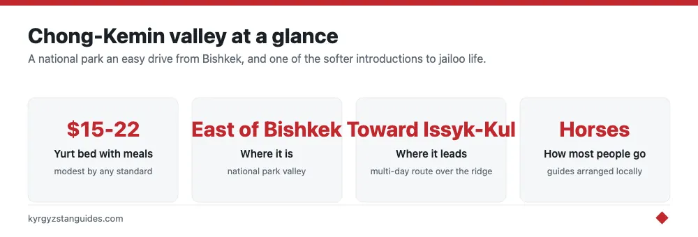
Chong-Kemin isn’t a turn-up-and-walk destination the way a signposted day hike is; the practical route is through a community-based tourism (CBT) network or a local operator. These arrange the pieces that make a multi-day trip work. A guide who knows the passes and river crossings, horses if you want them, and yurt or homestay accommodation with meals along the way. The gateway villages sit off the main highway east of Bishkek, and the simplest approach is to book ahead so a guide and horses are ready when you arrive rather than trying to improvise on the spot. Costs are modest by any standard — expect roughly $15-22 for a yurt bed with meals and a fair daily rate for a guide and horses — but carry cash, as there’s nowhere to pay by card once you leave the highway.
It’s worth being clear about the trade-off you’re making. Booking through a CBT or operator costs a little more than a self-guided day hike would, and it means fixing your dates in advance rather than deciding on a whim. In return you get logistics that would be genuinely hard to arrange alone (packhorses, a guide who reads the passes, and beds waiting each night) plus the cultural access that comes from a local who knows the herder families. For a multi-day mountain trip in a quiet valley, that’s money well spent, not a tourist markup to resent.
When to Go and What to Know
The season is essentially summer, roughly June to September, when the passes are clear of snow and the herders are up on the jailoo; outside that window the high route is snowbound and the pastures empty. This is a real mountain trek at altitude, so come with proper layers, a windproof shell, and sturdy boots, and treat the weather with respect even in July. The valley pairs naturally with a wider loop of the region: many people fold it into the journey toward the lake and continue to the Issyk-Kul basin afterward.
One honest caution before you commit. Because Chong-Kemin is quiet, it’s also less forgiving than a busy trail, fewer other trekkers means less help if something goes wrong, and phone signal disappears up-valley. This is not the place to freelance a solo route without a guide or to ride a horse for the first time far from any road. Book through a reputable CBT or operator, tell someone your plan, and don’t let the valley’s gentle lower reaches fool you into underestimating the high country above.
The park, in numbers
Chon-Kemin became a state natural park by government resolution No. 472 of 13 August 1997. It covers 123,654 hectares and protects six plant species and twenty-one animal species of conservation concern.
The valley is fed by the Chon-Kemin river, about 120 km long, a right tributary of the Chu, draining roughly 1,890 km². Half its annual runoff passes in three summer months, which is why it looks like a different river in April and July. Mean discharge at the mouth is 21.9 m³/s, dropping to 9.2 in March.
Elevation is one of those figures sources disagree on. The environment ministry gives the park's range as 1,400 to 2,800 m; another account puts the lowest point at 1,500 m and the highest at Peak Choktal, 4,771 m, the highest of the Kungey Ala-Too. The valley floor itself sits around 1,400-1,800 m. Take the floor figure for planning and treat the ceiling as contested.
The wildlife list is better than the walking suggests: 172 vertebrate species — 33 mammals, 117 birds, 11 reptiles, 2 amphibians, 9 fish — plus over 3,000 insect species. Six mammals are in the Kyrgyz Red Book, including brown bear, lynx and snow leopard, along with eleven birds. Around 650 plant species grow here, up to 30% of them Central Asian endemics.
There are 109 glaciers in the basin, the longest being Zhangyryk at 8.9 km. The two lakes worth knowing are Jashyl-Kol, moraine-dammed at the valley head where the Kungey and Zailiysky ranges meet, at somewhere between 3,120 and 3,450 m depending on the source, and Kol-Tor on the north slope at about 2,450 m, roughly 16 hectares.
The 1911 earthquake, and a mismatch nobody has resolved
On 3 January 1911 at 23:25 UTC, which was early on 4 January locally, this valley produced one of the largest continental earthquakes ever recorded. Around 400 people died, most of the damage falling on Verniy, now Almaty.
Here is the part that makes it genuinely interesting rather than just big. Seismologists, relocating the event from the original seismograms, put it at Mw 8.02 with a rupture of roughly 260-300 km. Geologists who went out and mapped the surface break found something different: a cumulative rupture of 155-195 km across thirteen fault patches in six sections, with more than fifty offset landforms measured, average slip of three to four metres and a peak under fourteen. Their moment calculation comes out at Mw 7.78 to 7.91.
That is a factor of about 1.5 between the moment released on the faults you can walk along and the moment the seismograms recorded. Soviet-era literature adds a third number, Ms 8.2. Nobody has reconciled them.
Do not let anyone tell you the lakes here were dammed by that earthquake, though. Jashyl-Kol is described as moraine-dammed, and while tectonically dammed lakes are mentioned in the survey work on the Chon-Aksu section, which lakes those are has not been established in anything I could read.
Practical upshot for a walker: the valley you are crossing is an active fault trace. (The hills at the valley’s mouth hold Kutessay, once the USSR’s rare-earth mine.) The 1911 scarps are still legible in the landforms, and a guide who knows them can show you the offsets.
FAQ
Is Chong-Kemin a national park?
It is a state natural park, created by government resolution No. 472 of 13 August 1997, covering 123,654 hectares. It protects six plant and twenty-one animal species of conservation concern.
How high is the Chong-Kemin valley?
The valley floor runs about 1,400-1,800 m. The park's ceiling is disputed: the environment ministry says 2,800 m, while another account gives Peak Choktal at 4,771 m, the highest of the Kungey Ala-Too.
What wildlife lives in Chong-Kemin?
172 vertebrate species including 33 mammals and 117 birds. Six mammals are in the Kyrgyz Red Book — brown bear, lynx, snow leopard, stone marten, red deer and mountain sheep — along with eleven bird species.
What was the 1911 Kemin earthquake?
One of the largest continental earthquakes on record, on 3 January 1911, which killed around 400 people, mostly in what is now Almaty. Seismograms give Mw 8.02 over a 260-300 km rupture; field mapping of the surface break gives Mw 7.78-7.91 over 155-195 km. The two have never been reconciled.
How do you get to Chong-Kemin from Bishkek?
Roughly two to three hours east by road, on the way toward Issyk-Kul. It is usually arranged as a two-to-four day trek or horse trip through community tourism rather than walked in unsupported.
When is the season for Chong-Kemin?
Summer. Half the river's annual runoff passes in three summer months, and snow cover in the basin generally lasts from late October to mid-April, with a frost-free period of about 114 days.