Travelers get Konorchek wrong in two opposite ways. Some skip it because it is not alpine. No snow, no passes, so how good can it be? Others treat it as a roadside photo stop and walk in with half a liter of water. The first mistake costs you a canyon system that out-photographs most of the Tien Shan; the second costs you a genuinely miserable afternoon.
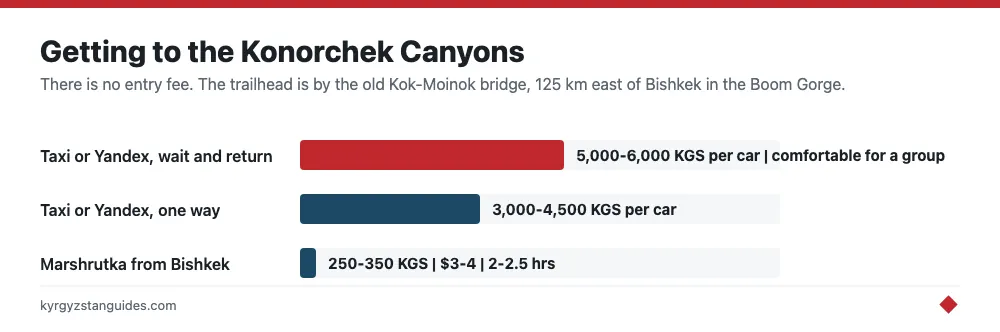
The facts: the Konorchek Canyons are a maze of red sandstone towers and dry gorges in the Boom Gorge, about 125 km east of Bishkek on the road to Issyk-Kul. There is no entry fee, the trailhead sits by the old Kok-Moinok bridge on the Bishkek–Balykchy highway, and the walk up the dry riverbed to the main formations takes 2-3 hours each way. All for the price of a 250-350 KGS marshrutka seat. It's the best day hike from the capital that requires no mountain gear at all.
What You Are Actually Hiking
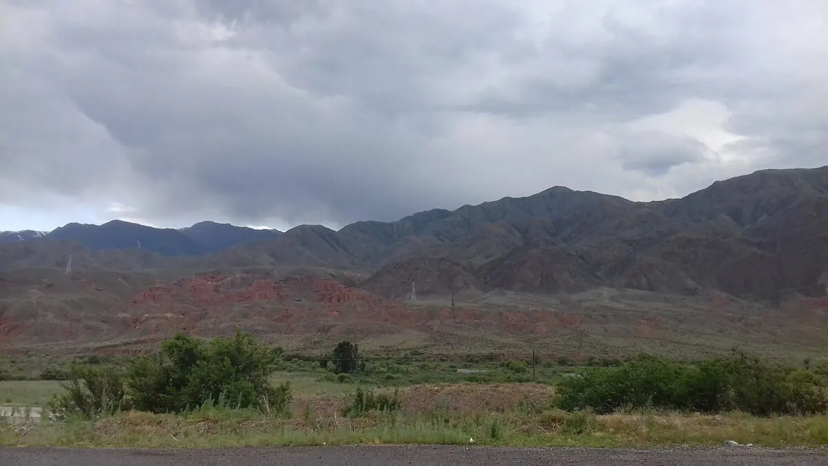
Konorchek is a system of eroded red sandstone and conglomerate canyons: eroded out of the Boom Gorge's southern wall, the corridor the Chüy River cuts between the Kyrgyz Ala-Too and Küngöy Ala-Too ranges. The named show-pieces are the Skeleton canyon and the wide amphitheater of hoodoo towers beyond it, with rust-colored cliffs of 60-100 m, plus one oddity at the top: a dark, cone-shaped hill whose slope stands out against the red rock, and which local accounts call an extinct volcano. Unlike Skazka Canyon on Issyk-Kul’s south shore, which is a 30-minute stroll, Konorchek is a proper hike — and that filters out the crowds.
Getting to the Trailhead
Any marshrutka toward Balykchy, Cholpon-Ata, or Karakol from Bishkek’s main bus station on Alma-Atinskaya 1/1 passes the spot; ask the driver for “Konorchek” or the Kok-Moinok bridge. They know it. Budget 250-350 KGS ($3-4) and 2-2.5 hours. A taxi or Yandex intercity runs 3,000-4,500 KGS one way per car; for a group, a wait-and-return deal at 5,000-6,000 KGS is the comfortable option. From the highway, cross the footbridge over the Chüy River by the abandoned railway bridge and follow the obvious path into the canyon mouth. Save the trailhead on Organic Maps or Maps.me before leaving — signage is minimal and mobile data in the gorge is patchy. For the return, flag down a passing marshrutka on the highway; before mid-afternoon this is reliable.
The Route, in Three Stages
The standard route follows a bone-dry riverbed upstream, flat to gently rising on sand and gravel: easy underfoot, with heat and distance doing all the damage. Pick your turnaround point:
- First red towers — 8-10 km round trip, 3-4 hours, easy. The walls turn deep red after 60-90 minutes of walking.
- Main hoodoo amphitheater — 12-14 km round trip, 4-6 hours. This is the classic: most people picnic here, scramble to a rim viewpoint, and turn back.
- Volcano cinder cone — 16-18 km round trip, 6-8 hours. Fit hikers with an early start only; the crater rim gives the best panorama of the whole system, with the snowy Küngöy Ala-Too floating behind.
The canyon floor sits at only 1,500-1,700 m, so this is training for the legs, not the lungs — a good warm-up before bigger routes like Ala-Kul.
Costs: Effectively Zero
No gate, no ticket, no infrastructure. A marshrutka-based day from Bishkek totals 500-700 KGS ($6-8) for transport plus whatever picnic you carry from a supermarket or Osh Bazaar. Occasionally a local collects an informal “parking” fee of 50-100 KGS by the bridge; take it with good humor. The flip side of free is that there are no toilets, no kiosk, no water, no shade, and nobody to call — you are self-sufficient from the moment you leave the highway. Trail shoes beat boots on the sand and gravel, and a windbreaker belongs in spring and autumn, when the gorge funnels wind; the full gear thinking is in our Kyrgyzstan packing list.
When to Go. And the Issyk-Kul Link-Up
April-May and September-October are ideal: 18-25°C, stable weather, softer light on the red rock. June to August works with a dawn start and extra water, but midday in the canyon is punishing. Clear winter days work too, the canyons are strangely handsome under a dusting of snow, making this one of the few Kyrgyz hikes feasible in January, though the footbridge area ices up. Konorchek is at its best exactly when the high mountains are not; our best time to visit Kyrgyzstan overview shows how it slots into a bigger trip.
The smartest itinerary is not an out-and-back from Bishkek at all. Hike in the morning, then flag an eastbound marshrutka and be swimming in Issyk-Kul by evening — Balykchy is 40 minutes on, Cholpon-Ata about 1.5 hours. It works just as well in reverse, as a leg-stretch on the ride back from Karakol. The gorge is cut by the Chu, which rises in the Tien Shan and flows north through the Boam gorge into the Chuy valley. The railway shares the same gap: a cliff-hugging, largely single-track line running from the Kazakh border through Bishkek to Balykchy.
Two Hazards. Take Both Seriously.
First, dehydration. The canyon is a sun trap with zero shade and no springs, and Boom Gorge summers regularly pass 35°C. Carry 2-3 liters of water per person, plus sunscreen, a sun hat, and electrolytes in July. The riverbed is dry for a reason.
Second, flash floods. That dry riverbed drains the entire canyon system, and a thunderstorm over hills you cannot even see from inside the slots can send water through fast. Check the forecast, skip the hike after heavy rain or when storms are building, and never camp in the riverbed itself. These are standard slot-canyon rules worldwide, and they apply fully here. Respect both and Konorchek is a safe, navigationally simple, absurdly photogenic day out.
The volcano story, and what the geology actually says
You will read everywhere that the dark cone above Konorchek is an extinct volcano, sometimes with a name attached. It is worth knowing that no geological source supports this. The claim appears only on travel sites, including Kyrgyz ones, and in none of the scientific literature.
What the peer-reviewed description of the Boom Gorge says is that the Chu river here is incised into Neogene sedimentary rocks over Paleozoic crystalline basement. The badlands are eroded basin fill. Nothing in that is volcanic.
The relevant units are the same ones that build Skazka on Issyk-Kul's south shore: the Chu Formation, around 1.5 km of mudstone and sandstone, and the coarse conglomerate of the Sharpyldak Formation above it, dated by fossil evidence to roughly 3.5 to 1.5 million years, with the lower part younger than 2.6 million. A caveat worth stating: the measured section for those figures is on the north flank of the Kyrgyz Range, not in the Boom Gorge itself, so read it as the regional stratigraphy rather than a Konorchek measurement.
Two other things get repeated without support. The formations are often dated to "1.5 to 2 million years", which has no source behind it. And one Kyrgyz portal mentions seashells from an ancient sea, which cannot be right for a continental basin fill.
None of this makes the cone less striking. It just means that if a driver tells you it erupted, he is repeating a story rather than reporting a fact — and that the real explanation, a river cutting three kilometres of accumulated basin sediment into badlands, is arguably the better one.
What the route figures actually are, and what is not documented
Published hike figures disagree by a factor of three. One set gives 4 km one way, about three hours' walking, 250 m of ascent, topping out near 1,750 m. Another gives 12 to 14 km total over three to five hours. Both come from tour operators. Plan for the longer version and be pleased if it is the shorter one.
The site itself: about 120 km east of Bishkek, trailhead at the Boom Gorge bridge, reachable by taking a Bishkek-to-Balykchy bus from the West Bus Station and getting off at the bridge. Entry is free. The main path to the canyon runs about 5 km and narrows to roughly 1.5 m in places.
The conditions are the real planning constraint, and one Kyrgyz portal is blunt about them: no mobile network, no guesthouses, no shops and no water sources, with summer highs around 40 °C. Spring and autumn are the sensible seasons.
One honest gap. Flash flooding in a dry canyon is an obvious hazard and it is widely warned about, but I could find no documented incident, rescue report or emergencies-ministry warning specific to Konorchek in either Russian or English. That is not evidence it is safe. It means nobody publishes a record, so you are making the call yourself: do not enter the narrows if rain is forecast or if the sky upstream looks wrong.
Nor could I confirm a railway halt. The Bishkek-Balykchy line runs through the Boom Gorge and walkers commonly talk about starting from a stop near Kok-Moinok, but no timetable or station name from the railway operator could be found. Plan on the bus.
FAQ
Is there really a volcano at Konorchek?
No geological source supports it. The dark cone is widely called an extinct volcano on travel sites, but the peer-reviewed description of the Boom Gorge is Neogene sediment over Paleozoic basement. Treat the volcano as local legend.
How long is the Konorchek canyons hike?
Sources disagree sharply: one operator gives 4 km one way over about three hours with 250 m of ascent, another gives 12-14 km over three to five hours. Plan for the longer figure.
How do you get to Konorchek from Bishkek?
It is about 120 km east. Take a Balykchy-bound bus from Bishkek's West Bus Station and get off at the Boom Gorge bridge. Entry to the canyons is free.
Is Konorchek dangerous?
There is no published accident record, which is not the same as being safe. The real risks are heat — summer highs near 40 °C with no water sources on site — no mobile signal, and flash flooding in narrow sections. Do not enter the narrows if rain is forecast.
When is the best time to hike Konorchek?
Spring and autumn. Summer is dangerously hot in an exposed canyon with no water, and there are no shops, guesthouses or mobile coverage on site.
How old are the Konorchek formations?
A few million years. The regional units are the Chu and Sharpyldak formations, dated by fossil evidence to roughly 3.5 to 1.5 million years. The commonly quoted '1.5 to 2 million years' has no source behind it.