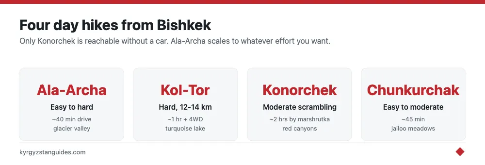
One of the quietly great things about Bishkek is how fast the flat, dusty city gives way to real mountains. The best day hikes within reach are Ala-Archa (glacier valley, easy-to-hard, ~40 min drive), Kol-Tor (turquoise glacial lake, hard, ~1 hr + 4WD), the Konorchek canyons (red-rock badlands, moderate, ~2 hr drive) and Chunkurchak (rolling jailoo meadows, easy-moderate, ~45 min). All four are doable as a there-and-back day from the capital, and each offers a completely different landscape.
What separates them is difficulty, access and scenery, not distance from the city — they’re all roughly an hour or two out. Below we rank them by what you’re actually signing up for, so you can match a trail to your fitness, your transport, and how much of a mountain day you want. None of these needs technical skill, but two of them will genuinely test your legs.
Ala-Archa National Park: The Default Choice
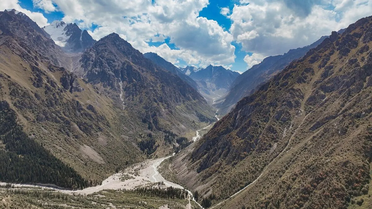
If you do only one hike from Bishkek, make it Ala-Archa. It’s the closest serious mountain terrain to the city, under an hour to the Alplager trailhead, and it flexes to your ambition. A gentle valley-floor walk suits families; the climb to the Ak-Sai waterfall is a satisfying half-day; and strong hikers can push all the way to the Ratsek climbers’ hut at 3,380 m and back if they start early. The park has a staffed gate and an entrance fee, and there’s no public transport in, so you’ll want a taxi or private car for the day. For the full breakdown of trails, fees and the overnight options, see our Ala Archa National Park guide.
Kol-Tor Lake: The Hard Reward
Kol-Tor is the trophy hike: a slim, milky-turquoise glacial lake high in a side valley off the Chunkurchak gorge, reached on a demanding 12-14 km round trip with 600-800 m of climbing. Plan on 5-7 hours of walking, finishing around 2,700 m, on a path that steepens and turns rocky near the top. The catch is access — the final unpaved stretch to the trailhead needs a 4WD or high-clearance vehicle, so this isn't a public-transport day out. The color of the lake on a sunny afternoon justifies the effort, but respect the grade; people underestimate it because it’s a “day hike” near a capital. The trailhead sits up the Chunkurchak gorge, and getting a car that can reach it is half the planning.
Konorchek Canyons: The Red-Rock Detour
Konorchek is the odd one out and all the better for it — instead of alpine valleys you get a Martian landscape of eroded red-rock canyons and hoodoos, a couple of hours east of Bishkek on the road toward Issyk-Kul. The hike from the highway involves crossing the valley (sometimes a rail bridge and a riverbed) and then walking up into the canyon system, moderate underfoot with some scrambling, and hot and shadeless in summer. Because it sits right on the Bishkek-Issyk-Kul road, it’s the easiest of the four to reach by public transport — any Karakol-bound marshrutka can drop you near the trailhead. It pairs naturally with a lake trip. See our full Konorchek canyons hike guide for the river-crossing and timing specifics.
Chunkurchak: The Easy Meadow Day
The Chunkurchak (Chunkurchak) valley is the gentle option — rolling green jailoo meadows, grazing horses, and low ridgelines with long views, about 45 minutes south of the city. It’s popular with locals for picnics and easy walks, and in winter it hosts a small ski area, so infrastructure is better than at the wilder trailheads. You can wander for a couple of easy hours or link ridges for a fuller half-day without ever facing a lung-busting climb. It’s the pick for a relaxed day, for less-fit walkers, or as a warm-up before tackling Kol-Tor, whose trailhead lies further up the same gorge system.
One more valley belongs on any Bishkek day-hike list: Shamsi — once a hunting concession, today a snow leopard sanctuary, ninety minutes out of the capital, with no ticket, no facilities and hardly another walker in sight.
Compare the Four at a Glance
| Hike | Difficulty | Access | Scenery |
|---|---|---|---|
| Ala-Archa | Easy to hard (your call) | ~40 min drive; car needed, park fee | Glacier valley, waterfall, peaks |
| Kol-Tor | Hard, 12–14 km | ~1 hr + 4WD to trailhead | Turquoise glacial lake |
| Konorchek | Moderate, some scrambling | ~2 hr; reachable by marshrutka | Red-rock canyons, hoodoos |
| Chunkurchak | Easy to moderate | ~45 min drive | Rolling jailoo meadows |
Practical Notes for All Four
A few things apply across the board. The hiking season is roughly May to October, with the high trails (Kol-Tor, upper Ala-Archa) only reliably clear from June. Mountain weather turns fast in the afternoon, so start early and carry a shell whatever the morning looks like. Except for Konorchek, none of these is a real public-transport hike, so budget for a taxi or private car, a half-day charter from Bishkek is the simplest fix, and splitting it between a few people keeps it cheap. Carry cash in small som notes for gate and parking fees, sturdy shoes for the rocky trails, and more water than you think you’ll need. Phone signal is patchy to nonexistent in the gorges.
Which Should You Pick?
Short version: Ala-Archa for the best all-rounder and the most flexible day; Kol-Tor if you’re fit and want the standout view; Konorchek if you want something visually different and easy to reach without a car; Chunkurchak for a relaxed, low-effort day in the meadows. If you’ve got several days in the city, do two of them (an easy one and a hard one) and use the rest of your time on the sights in town. Line them up alongside our roundup of things to do in Bishkek, and if any of these whets your appetite for something longer, our Kyrgyzstan trekking guide maps out the multi-day routes worth planning a trip around.
One longer route of that kind: the Kegeti pass, above the Kegeti waterfall, tops out at 3,805 metres on its way over to Kochkor — not, whatever you may have read, to Chong-Kemin.
Ala-Archa’s trails, with the park’s own numbers
Most trail figures online come from apps. These are the park’s, which it says follow real mapped trail data, given as one-way distances:
Broken Heart rock — 2.4 km, easy. Tepshi plateau — 2.0 km, easy, topping out at 2,580 m. Ak-Sai waterfall — 3.9 km, moderate, 2,860 m. Ratsek Hut — 5.7 km, hard, 3,380 m.
Note what those are: distance and destination altitude. The park does not publish elevation gain, so the ascent figures circulating for Ak-Sai and Ratsek come from third-party apps rather than the park.
The park covers 36,200 hectares, its highest peak is 4,895 m, it records over 155 bird species, and it claims more than fifty trails.
Nobody officially marks the trails
This is the thing to internalise before setting off on anything beyond the obvious. No Kyrgyz state body claims to waymark hiking trails. What exists is work by destination organisations, CBT offices and NGOs.
The national destination organisation describes the Kyrgyz Nomad Trail as a network of over 2,000 km across eighteen mapped sections, while warning in the same breath that signage is thin off main routes, and recommending section hikes rather than end-to-end attempts. Take the warning as seriously as the network.
Season, from the same source: the core window is June to September, peaking in July and August, with October narrowing you to lower elevations unless you have cold-weather experience.
What happens if it goes wrong
There is one number: 112, the unified emergency dispatch service run by the Ministry of Emergency Situations. The ministry’s emergency line is +996 550 112 765.
Mountain rescue does function, and Ala-Archa sees it regularly — documented evacuations include an injured tourist brought down from near Ratsek hut, climbers found near the Korona shelter, and a teenager evacuated at two in the morning. The rescue squad covering the valley is reported as Edelweiss.
But be clear about the standard. The national destination organisation’s own wording is that in Kyrgyzstan serious injuries usually mean stabilisation and a long ground transfer before advanced care, and that standard travel insurance often excludes high-altitude trekking. Whether rescue is free of charge to foreigners is not something I could establish.
For the current Ala-Archa access rules, including the car ban and the June 2026 fee rise, see our Ala-Archa guide.
Frequently Asked Questions
What is the best day hike from Bishkek?
Ala-Archa National Park is the best all-round choice. It’s the closest serious mountain terrain to the city, under an hour away, and its trails scale from easy valley walks to a hard climb to the Ratsek hut. For a standout single view, Kol-Tor’s turquoise glacial lake is the pick, though it’s a much harder day.
Can you do these hikes without a car?
Only Konorchek is doable by public transport, since any Karakol-bound marshrutka can drop you near its trailhead on the Issyk-Kul road. Ala-Archa, Kol-Tor and Chunkurchak effectively need a taxi or private car; a shared half-day charter from Bishkek is the usual solution.
When is the hiking season around Bishkek?
Roughly May to October, with the higher trails like Kol-Tor and upper Ala-Archa only reliably clear of snow from June through September. Start early regardless, because mountain weather tends to turn in the afternoon.
How long are the trails in Ala-Archa?
The park's own one-way figures: Broken Heart rock 2.4 km (easy), Tepshi plateau 2.0 km (easy, topping out at 2,580 m), Ak-Sai waterfall 3.9 km (moderate, 2,860 m) and the Ratsek hut 5.7 km (hard, 3,380 m). The park publishes distance and destination altitude but not elevation gain, so ascent figures circulating online come from third-party apps.
Are hiking trails marked in Kyrgyzstan?
No state body claims to waymark them. What exists is work by destination organisations, CBT offices and NGOs. The national destination organisation describes the Kyrgyz Nomad Trail as over 2,000 km across eighteen mapped sections while warning in the same breath that signage is thin off main routes, and recommends section hikes rather than end-to-end attempts.
What number do I call in a mountain emergency in Kyrgyzstan?
112, the unified emergency dispatch run by the Ministry of Emergency Situations; the ministry's emergency line is +996 550 112 765. Mountain rescue does function and Ala-Archa sees it regularly. But the realistic standard is stabilisation and a long ground transfer before advanced care, and standard travel insurance often excludes high-altitude trekking.
How hard is the Kol-Tor hike?
Harder than its day-hike billing suggests: 12–14 km round trip with 600–800 m of climbing, 5–7 hours of walking, finishing around 2,700 m on a path that steepens and turns rocky near the top. The final unpaved stretch to the trailhead also needs a 4WD or high-clearance vehicle.