The Pamir Highway climbs to 4,655 m at the Ak-Baital Pass, one of the highest road passes in the world, and the Kyrgyz half begins in Osh. From there the M41 runs roughly 700 km south and over the border into Tajikistan’s Pamirs, and the classic overland trip is Osh to Khorog or Dushanbe, done in three to five days with a hired 4WD.
This is a serious high-altitude drive, not a bus route. There is no through public transport across the Kyzyl-Art border, you sleep at 3,600– 4,000 m for several nights, and the Tajik side sits inside a special permit zone that has periodically closed to tourists. Read the border-crossing overview and check the region’s current status before you commit money to it.
Where the Pamir Highway starts: Osh
Almost everyone starts the southbound Pamir run in Osh, Kyrgyzstan’s second city and the country’s southern hub. Osh has an airport with cheap flights from Bishkek (around $40– 60), guesthouses, ATMs, SIM cards and the agencies that arrange Pamir jeeps. It's the last place with reliable banking and good supplies, so stock up here: cash in small USD bills, snacks, and any altitude medication.
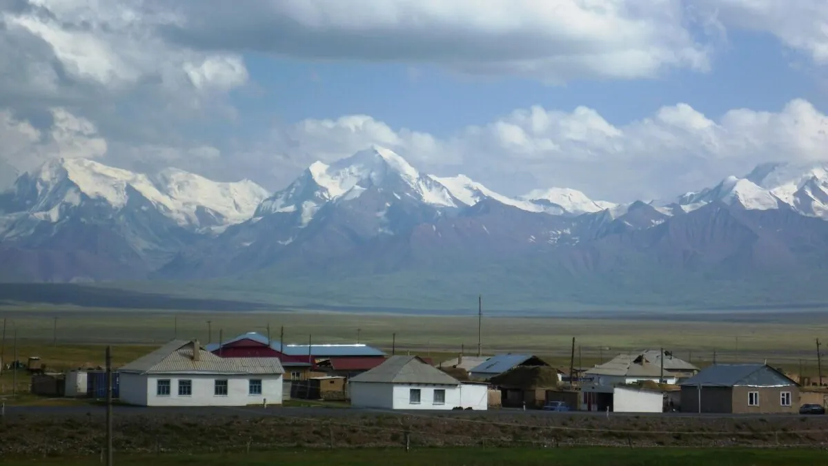
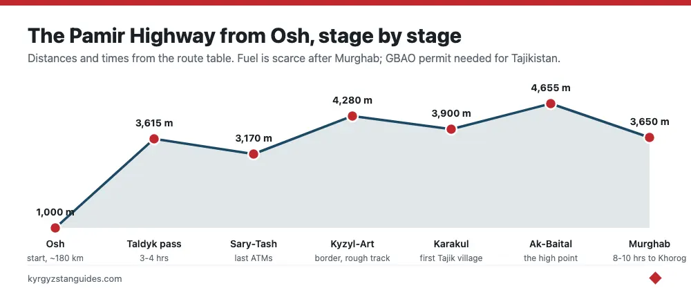
From Osh the road runs to Sary-Tash, a windswept junction village at about 3,170 m where three routes split: east to China at Irkeshtam, south to Tajikistan over the Kyzyl-Art pass, and back north to Osh. Sary-Tash is roughly 180 km and three to four hours from Osh on paved but winding road, crossing the Taldyk Pass (3,615 m). Most travelers overnight in a Sary-Tash homestay before the border push.
The route, stage by stage
The Kyrgyz section is short but slow. Once you cross into Tajikistan the distances stretch and the settlements thin out to a handful of villages. Here is the classic Osh– Khorog run most drivers follow.
| Stage | Distance | Rough time | Notes |
|---|---|---|---|
| Osh → Sary-Tash | ~180 km | 3– 4 hrs | Over Taldyk Pass (3,615 m); last town with ATMs |
| Sary-Tash → Kyzyl-Art border | ~75 km | 2– 3 hrs | Rough track; Kyzyl-Art pass ~4,280 m |
| Border → Karakul | ~65 km | 2 hrs | Lake Karakul at 3,900 m; first Tajik village |
| Karakul → Murghab | ~130 km | 3– 4 hrs | Over Ak-Baital 4,655 m; Murghab at 3,650 m |
| Murghab → Khorog | ~310 km | 8– 10 hrs | Via Wakhan or main M41; fuel scarce |
Some travelers detour west into the Alay valley toward Sary-Mogol for views of Pik Lenin before turning for the border; if you have the days, the Pik Lenin base camp area is worth the diversion. Others push straight through and reach Murghab on day two.
Between Murghab and Khorog you also choose your line. The main M41 continues northwest over more high passes, while the Wakhan Corridor route swings south along the Panj River, with Afghanistan on the far bank, Silk Road forts and hot springs — slower and rougher, but the scenic highlight of the whole highway for most people. If your driver and permit allow it and you have an extra day, take the Wakhan.
What the drive is actually like
Set your expectations for a rough, remote, physically tiring road rather than a scenic cruise. Long stretches beyond Sary-Tash are unpaved, washboard corrugations and potholes are constant, and average speeds drop to 30– 40 km/h on the worst sections. You'll stop at several military and permit checkpoints where a soldier logs your passport and GBAO permit by hand, which adds time but is routine. Cell coverage is patchy to nonexistent for hours at a stretch, so nobody is reachable mid-route.
Days in the vehicle run long, eight to ten hours is normal on the Murghab– Khorog leg, broken by tea stops at village homes and photo stops at passes and lakes. Breakdowns happen; a competent Pamir driver carries spare tires, tools and fuel and can improvise repairs, which is exactly why hiring an experienced local driver beats trying to self-drive a rental. This is not a road to attempt on a tight schedule or with a low-clearance car.
Where you will sleep
Accommodation along the route is simple homestays and family guesthouses rather than hotels, and that's part of the appeal. In Sary-Tash, Karakul and Murghab, families take in travelers for roughly $10– 15 a night including dinner and breakfast. Usually a foam mattress on the floor of a warm room, a shared long-drop or basic bathroom, and hearty meals of soup, bread, potatoes and tea. Murghab, the largest Tajik settlement on the route at 3,650 m, has the most options and a small container-market bazaar for supplies.
Book nothing in advance for most of these. You arrange them on arrival or your driver knows families along the way. Bring a warm sleeping bag liner or your own bag for comfort and hygiene, because nights are cold even in summer at these altitudes and heating is minimal. A head-torch is essential for the walk to outdoor toilets after dark.
Money, fuel and connectivity
Treat the whole trip as a cash economy with no safety net. There is no reliable ATM after Osh, cards are useless in the villages, and even Murghab’s banking is unreliable, so bring enough cash in small US dollar bills and Kyrgyz som to cover the entire trip plus a buffer. Fuel along the Tajik side is often sold from barrels at inflated prices, and stations can be dry, which is another reason drivers carry jerrycans; factor fuel into your vehicle deal so there are no arguments later.
Connectivity is minimal. A Kyrgyz SIM works around Osh and Sary-Tash but not across the border, and Tajik coverage is limited to the larger villages. Download offline maps before you leave, tell someone your rough itinerary, and accept that you'll be off-grid for long stretches. For many travelers that disconnection is a feature, not a bug.
GBAO permit and the Tajik visa
The entire Tajik side of the highway lies inside the Gorno-Badakhshan Autonomous Oblast (GBAO), and you need a GBAO permit on top of your Tajik visa to travel there. Most nationalities apply online for the Tajik e-visa and add the GBAO permit as a tick-box during the same application. Budget roughly $50 for the e-visa and about $20 for the GBAO add-on, and apply a week or two ahead.
Carry printed copies. There are checkpoints at the border and inside GBAO where officials record permit and passport details. Kyrgyzstan itself is visa-free for many nationalities and offers an e-Visa for others, including Indian passport holders, so the Kyrgyz side of the trip is straightforward paperwork; the Tajik permit is the piece people forget.
Hiring a jeep: shared vs private
There is no scheduled transport across the border, so you either join a shared jeep or hire a private 4WD with driver. Shared taxis run Osh– Sary-Tash for around 500– 800 KGS a seat, but onward across the border you generally arrange a driver. A private 4WD from an Osh or Sary-Tash agency for the multi-day run to Khorog typically costs $400– 700-plus for the vehicle, split between up to four passengers.
Community-Based Tourism (CBT) offices in Sary-Tash and Sary-Mogol are the reliable local fixers for drivers and homestays. Booking through them keeps money local and gets you a driver who knows the passes. For the wider picture on marshrutkas, shared taxis and 4WD hire across the country, see our guide to getting around Kyrgyzstan.
- Agree the full route, overnight stops and who pays for fuel before you leave.
- Confirm the vehicle is a real 4WD, not a sedan, the Kyzyl-Art track punishes low clearance.
- Carry enough cash for the whole trip; there's no reliable ATM after Osh.
- Bring your own snacks and plenty of water; roadside options are minimal.
Independent, shared, or a full tour?
There are three realistic ways to do this. The cheapest is fully independent: piece together shared taxis and drivers segment by segment, negotiating each leg, which saves money but eats days and Russian or a translation app helps a lot. The middle path most travelers take is to hire one 4WD and driver for the whole Osh– Khorog run and fill the four seats with other travelers you meet in Osh guesthouses, splitting the cost. The most expensive is a packaged tour booked from home, which locks in the vehicle, permits and homestays but costs considerably more.
For a first-timer we lean toward the shared-4WD-with-driver option arranged in Osh or through a Sary-Tash CBT office: you keep costs reasonable, get a driver who knows the passes and paperwork, and retain flexibility over the route and stops. Whatever you choose, meeting fellow travelers a day or two ahead in Osh to form a group of four is the single biggest money-saver on this trip.
When to go
The season is short: mid-June to mid-September. Outside that window the high passes hold snow and can close without warning, and homestays shut down for winter. July and August are the safest bet for open roads and running guesthouses, though they are also when the road sees the most other travelers. For the country-wide picture on seasons and weather, our note on the best time to visit has the month-by-month detail.
Altitude and staying healthy
This is the part people underestimate. You gain altitude fast and then sleep high (Murghab is 3,650 m, Karakul about 3,900 m) for several consecutive nights. Acute mountain sickness is a real risk, especially if you fly into Osh (1,000 m) and start driving the next morning. Headaches, nausea and broken sleep are common even for fit travelers.
- Spend a night in Sary-Tash (3,170 m) before crossing, to break the climb.
- Drink far more water than feels necessary and go easy on alcohol.
- Ask a doctor about acetazolamide (Diamox) before you travel.
- If symptoms get worse rather than better, descend — that's the only cure.
What it costs
The Pamir Highway is cheap by the day but the jeep is the big line item. Here is a realistic per-person estimate for a shared 4WD trip, assuming four passengers splitting the vehicle.
| Item | Rough cost | Notes |
|---|---|---|
| Osh flight from Bishkek | $40– 60 | Optional; buses are cheaper but long |
| Tajik e-visa + GBAO permit | ~$70 | Applied online together |
| Shared 4WD (per person) | $120– 200 | If four split a $500– 700 vehicle |
| Homestays with meals | $10– 15/night | Sary-Tash, Karakul, Murghab |
| Food, snacks, extras | $10– 15/day | Carry cash; few shops en route |
Is it safe right now?
Two separate questions matter here. The driving itself is the usual high-mountain risk, rough tracks, altitude, remoteness, thin margins if a vehicle breaks down. That is managed with a good driver, a real 4WD and sensible pacing. The bigger variable is political: GBAO has seen unrest and security operations in recent years, and at times the Tajik authorities have suspended GBAO permits or closed the region to foreigners entirely.
Do not book a non-refundable trip until you have confirmed the current GBAO permit and access situation. Check your government travel advisory, ask Osh and Sary-Tash agencies what is actually running this month, and have a Plan B. For many travelers that means driving Osh to Sary-Tash and Pik Lenin on the Kyrgyz side only, which needs no Tajik permit and is spectacular in its own right.
Frequently Asked Questions
Do I need a GBAO permit for the Pamir Highway?
Yes, for the Tajik side. The whole route through Gorno-Badakhshan requires a GBAO permit on top of your Tajik visa. Most travelers add it to their online e-visa application for around $20 extra. The Kyrgyz section from Osh to the border needs no such permit.
Where does the Pamir Highway start in Kyrgyzstan?
In Osh, Kyrgyzstan’s southern hub. From Osh the M41 runs to Sary-Tash, a junction village, and then over the Kyzyl-Art pass into Tajikistan. Osh is the last town with reliable ATMs, fuel and agencies that arrange Pamir jeeps.
How many days does the Osh to Khorog drive take?
Three to five days is typical, with overnight stops in Sary-Tash, Karakul or Murghab. You can push it faster, but the altitude, rough tracks and photo stops make a relaxed three-to-four-day pace far more comfortable and safer for acclimatizing.
Is there public transport across the border?
No scheduled service crosses the Kyzyl-Art border. Shared taxis run Osh to Sary-Tash, but for the border and Tajik side you hire a driver or join a shared 4WD arranged through agencies or CBT offices in Osh, Sary-Tash or Sary-Mogol.
When is the Pamir Highway open?
Roughly mid-June to mid-September. The high passes hold snow outside that window and can close suddenly, while homestays shut for winter. July and August are the most reliable months for open roads and running guesthouses along the route.
What should you buy in Osh before driving the Pamir Highway?
Everything you cannot get later: cash in small USD bills, snacks, and any altitude medication. Osh is the last place with reliable banking, ATMs, SIM cards and good supplies before the M41 climbs south — Sary-Tash at 3,170 m is a windswept junction village, and settlements on the Tajik side thin out to a handful of villages for days.