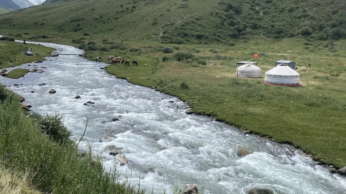
Stand at Besh-Tash lake on an August afternoon and the only company you're likely to have is a herding family, their horses, and possibly a park ranger on his rounds. This is a functioning national park with a turquoise alpine lake at 3,000 meters, a drivable valley road, and marked-on-the-map trekking routes, and it receives so few foreign visitors that guesthouse owners in Talas still remember individual travelers from previous seasons.
The reason is simple geography: Besh-Tash sits in Talas region, Kyrgyzstan’s northwestern pocket, which almost no itinerary touches. The Kyrgyz Department of Tourism records it as founded in 1996, 13 km from the town of Talas; its formal designation is a state nature park rather than a national park, and the UNEP-WCMC protected-area record lists it as IUCN category II. Getting there means either crossing a 3,300-meter pass from the Bishkek-Osh road or looping through Kazakhstan. For travelers willing to make that detour, the reward is a genuinely quiet corner of the Tien Shan plus Kyrgyzstan’s most important national shrine, Manas Ordo, twenty minutes from Talas town.
The Park in Brief
Besh-Tash (“five stones”) protects a long north-south valley running from the outskirts of Talas town up into the Talas Ala-Too range. A rough vehicle track follows the Besh-Tash river most of the way up the valley, past juniper slopes, summer yurt camps, and a couple of small reservoirs, ending near the main prize: Besh-Tash lake, a cold, intensely colored tarn under scree walls at around 3,000 meters. Entry costs a few hundred som per person plus a vehicle fee, paid at the checkpoint at the park entrance. Bring cash and small notes.
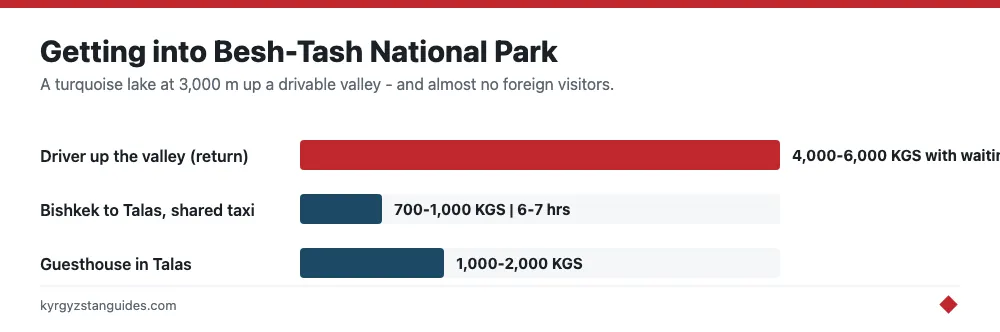
From Talas town to the lake is roughly 40 kilometers. A 4×4 or a well-driven Delica can get within a short walk of the lake in about two hours when the track is dry; regular sedans usually stop lower down, turning the last stretch into a half-day walk. Drivers in Talas ask somewhere around 4,000-6,000 KGS for the return trip with waiting time, and your guesthouse can usually arrange one by the next morning.
Walking and Riding
The straightforward option is the valley itself: get dropped partway up and walk to the lake, camp a night, and walk back down meeting the vehicle. As an introduction to Kyrgyz high country it is hard to beat for effort-to-scenery ratio, and the altitude gain is gentle enough for reasonably fit walkers who have spent a night or two above 1,500 meters.
Stronger parties can go further. Passes at the head of the valley connect Besh-Tash south toward the Suusamyr and Chatkal watersheds, and multi-day horse routes cross the range in several directions. This is classic terrain for the kind of guided horse journey we describe in our horse trekking guide. There is no trail signage and no rescue infrastructure, so for anything beyond the main valley you want a local guide or genuine self-sufficiency: navigation on your phone plus paper backup, camping gear rated for cold nights, and food for a spare day. The general principles in our Kyrgyzstan trekking guide apply here without modification.
Camping is allowed throughout the park. The meadows below the lake are the obvious spot, with water everywhere and flat ground easy to find. Nights are cold even in August (expect frost at the lake) and afternoon thunderstorms build fast on this side of the range, so pitch early.
One more thing worth saying about the emptiness: it changes how the trip feels. In Karakol’s valleys you share trails with other hikers and pass yurt camps built partly for tourists. Here the yurts are working summer households, the herders wave you over for kymyz because a visitor is an occasion, and the price of that authenticity is that nobody is selling you anything, no marked campsites, no horse rentals with signboards, no café at the trailhead. You negotiate everything person to person, usually in gestures and fragments of Russian. Some travelers find this the whole point of Kyrgyzstan; others find it exhausting. Know which one you are before you commit four days to Talas.
Pair It with Manas Ordo
Talas is the heartland of the Manas epic, the vast oral poem at the center of Kyrgyz identity, and Manas Ordo, the mausoleum complex and museum east of Talas town where the hero is said to rest, is the region’s cultural anchor. It's an easy half-day: a 14th-century mausoleum, a modern museum, and a hilltop viewpoint over the Talas valley. Whatever you make of the historicity, watching Kyrgyz families treat the site as a pilgrimage destination tells you more about the place of the epic in national life than any museum caption. Do it the day you arrive or depart, and give the park the full days in between.
Getting to Talas at All
This is the part that filters out the crowds. From Bishkek you have two options:
- Over the Ötmök pass: shared taxis and minibuses run daily from Bishkek’s western bus stand, following the Bishkek-Osh highway before branching west over the 3,330-meter Ötmök pass to Talas. Around 6-7 hours, roughly 700-1,000 KGS in a shared taxi. Open year-round but weather-dependent in winter.
- Through Kazakhstan: the old main road runs via Kazakh territory (Taraz), which is shorter in distance but involves two border crossings. Since most nationalities now enter Kazakhstan visa-free this corridor is usable again, but crossings add unpredictable time and most travelers should simply take the pass. If you do route through Kazakhstan, check current crossing status first — our border crossings guide covers the details.
In Talas town, a handful of guesthouses and small hotels offer beds for around 1,000-2,000 KGS. Do not expect English menus or tour desks; do expect to be asked, with real curiosity, why you came.
Before You Go: The Short Checklist
- Season: mid-June to mid-September for the lake; the upper valley holds snow outside that window.
- Cash in som for park fees, drivers, and guesthouses. No card payments anywhere past Bishkek on this route.
- Camping gear if you want the lake at dawn, which you do; day-trippers see it at its flattest midday light.
- Warm layers regardless of month. Frost at 3,000 meters in August is normal, not bad luck.
- A spare half-day for Manas Ordo, and low expectations for infrastructure everywhere else.
Two full days in the park plus one for Manas Ordo and transit makes a satisfying three-to-four-day detour. If your route already runs the Bishkek-Osh highway, the turnoff at Ötmök costs you far less than the emptiness on the other side pays back.
The numbers, and where they disagree
Besh-Tash is a state nature park rather than a national park in the strict sense, founded in 1996, and it runs about 30 km along the Besh-Tash river into the Talas Ala-Too.
Its area is genuinely contested. The world protected-areas database lists 137.32 km², or 13,732 hectares. Kyrgyz sources describe it as more than 30,000 hectares, and one gives around 32,400. That is a factor of more than two, and no reconciling source could be found, so treat the small figure as the registered one and the large figure as what is locally claimed.
Elevation runs from about 1,100 m in the foothills to 3,500 m at the glaciers, with an upper figure of 3,600 also quoted. The park holds over 800 plant species including Semenov’s fir and Persian rowan, with eleven in the Kyrgyz Red Book.
Lake Besh-Tash sits at close to 3,000 m. Its depth and area are quoted online but from a source I could not open, so I am not going to give you numbers for them.
Getting in, and what it costs
An ordinary car reaches the ranger post. Beyond that it is 20 to 25 km of good gravel, with walking or a 4x4 advised for the final section. From Talas town to the lake is roughly 40 km.
Entry is reported at 250 som per person or 400 som per vehicle. I could not find an official tariff page, so treat that as indicative and bring small notes.
Season: May and June for wildflowers, July and August when the passes are open and it is warmest, September for autumn colour. Winter access is limited or blocked by snow.
Two things frequently claimed about the park that I could not source at all: the presence of snow leopard, lynx and ibex, which is plausible for this terrain but unverified here, and any named waterfalls. If a guide names a waterfall for you, that is local knowledge rather than anything published.
FAQ
Is Besh-Tash a national park?
Formally it is a state nature park, founded in 1996, running about 30 km along the Besh-Tash river in the Talas Ala-Too. The Kyrgyz ministry lists it among the country's state nature parks.
How big is Besh-Tash park?
Disputed. The world protected-areas database gives 137.32 km², about 13,732 hectares; Kyrgyz sources claim more than 30,000 hectares. No source reconciles the two.
How much does Besh-Tash cost to enter?
Reported at 250 som per person or 400 som per vehicle. No official tariff page could be found, so treat it as indicative and carry small notes.
When is the best time to visit Besh-Tash?
May and June for wildflowers, July and August for open passes and the warmest weather, September for autumn colour. Winter access is limited or snowbound.
How do you get to Besh-Tash lake?
From Talas town it is roughly 40 km. An ordinary car reaches the ranger post; the last 20 to 25 km is good gravel, with walking or a 4x4 advised for the final stretch. The lake sits near 3,000 m.
What wildlife is in Besh-Tash?
Over 800 plant species including Semenov's fir and Persian rowan, eleven of them in the Kyrgyz Red Book. Claims about snow leopard, lynx and ibex are plausible for the terrain but could not be verified from any source.