Let’s be upfront: the Chatkal Valley is not for most travelers. It sits in Kyrgyzstan’s far west, wedged between the Talas range and the Uzbek border, and there's no easy way in. No paved highway runs its length, no marshrutka network serves its villages reliably, and phone signal disappears for long stretches. If Song-Kul feels remote to you, Chatkal is a different category altogether.
Here is the short answer for the impatient: the Chatkal Valley is worth the effort only if you have at least five spare days, your own 4×4 or a driver who knows the passes, and a genuine appetite for places where tourism infrastructure simply does not exist. What you get in return is one of Central Asia’s great wild rivers, the western edge of the walnut-fruit forest belt, and valleys where a foreign visitor is still an event. What you give up is comfort, predictability, and any kind of backup plan.
Where the Chatkal Valley Actually Is
The Chatkal River rises in a snowy ravine of the south-western Talas Alatau spurs and flows for roughly 200 kilometers, most of it through Kyrgyz territory, before crossing into Uzbekistan, where it eventually feeds the Charvak reservoir near Tashkent. The Kyrgyz section of the valley belongs administratively to Jalal-Abad region, but geographically it's closer to Talas, which tells you something about how awkward it's to reach from anywhere.
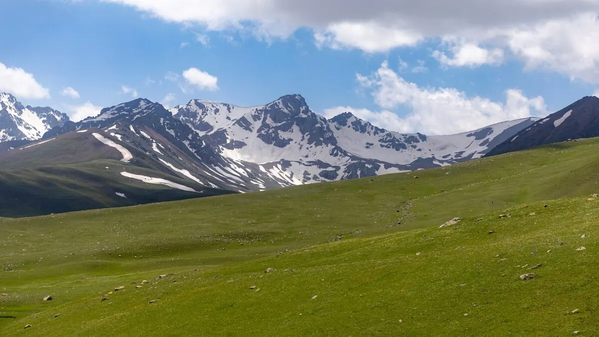
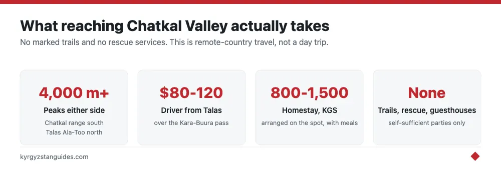
The valley is hemmed in by the Chatkal range to the south and the Talas Ala-Too to the north, with peaks pushing past 4,000 meters on both sides. The main settlements — Kanysh-Kyya (the district center), Terek-Say, and a scattering of mining and herding villages — are small, functional places. Kanysh-Kyya has a bazaar, a few shops, and basic guesthouse-style rooms if you ask around, but nothing you could call a hotel.
Getting In: Two Hard Roads
Option 1: Over the passes from Talas
The classic approach runs south from Talas town over the Kara-Buura pass, at roughly 3,300 meters. The road is unpaved, rough, and typically open from around June to early October. Snow closes it for the rest of the year. In a capable 4×4 with an experienced driver, Talas to Kanysh-Kyya takes a full day. Hiring a driver in Talas usually costs somewhere in the range of $80-120 for the run, more if you want the vehicle to stay with you, and you should negotiate hard and confirm the pass is actually open before committing. Our advice on getting around Kyrgyzstan applies double here: the vehicle matters more than the price.
Option 2: The long way from Jalal-Abad
From the south, a road climbs from the Fergana valley side via Ala-Buka toward Chatkal. Parts of this route thread close to the Uzbek border, and the border geography here is genuinely messy, enclaves, disputed stretches, and checkpoints that may want to see your passport. Carry it at all times, keep your registration slip if you have one, and read up on Kyrgyzstan’s border crossings before you travel this way. The drive from Jalal-Abad city is long. Budget a full day again, but the road stays open more of the year than Kara-Buura.
There is no realistic public-transport option for either route. Shared taxis run sporadically from Talas and from Ala-Buka when there are enough passengers, but schedules don't exist and you can wait a day or more. Treat public transport here as a bonus if it happens, not a plan.
What You Actually Do There
The river
The Chatkal is the valley’s main event. Among Central Asian paddlers it has a serious reputation: sustained class III-IV whitewater in a deep, committing gorge, usually run as a multi-day expedition in late summer when the glacial melt settles down. A handful of Bishkek- and Tashkent-based operators run guided descents in August and September, typically 5-8 days with full camping support. This is expedition rafting, not a tourist float, you sign up through an operator months ahead, you don't show up and arrange it locally.
Walking and horse country
Side valleys climb north and south from the river toward high pastures that see almost no trekkers. There are no marked trails, no guesthouse networks, and no rescue services, so this is territory for self-sufficient parties with camping gear, or for travelers who hire a local horseman as guide: ask in Kanysh-Kyya, expect to pay roughly 2,000-3,000 KGS per day for a guide with horses, and expect the arrangement to be improvised. The Besh-Aral nature reserve occupies the lower valley and protects, among other things, one of the last populations of the Menzbier’s marmot; entry formally requires a permit arranged through the reserve office.
The forest edge
The famous walnut-fruit forests of southern Kyrgyzstan, the ones that draw visitors to Arslanbob. Have their western outliers in the lower Chatkal basin. You'll find wild fruit and nut trees scattered through the lower side valleys, though nothing on Arslanbob’s scale. If forests are your main interest, Arslanbob honestly serves you better for a fraction of the logistics.
Practicalities, Honestly Stated
- Season: late June to September. Outside that window, the Kara-Buura pass is shut and the valley effectively closes to visitors.
- Sleeping: homestays arranged on the spot in Kanysh-Kyya and villages (roughly 800-1,500 KGS with meals), or your own tent. Book nothing online, because there is nothing online.
- Food and fuel: shops in Kanysh-Kyya cover basics. Bring anything specialized, gas canisters, snacks, medicines, from Bishkek or Talas.
- Money: cash only, in som. No reliable ATMs.
- Connectivity: patchy at best in villages, absent in the side valleys. Tell someone your plan before you go dark.
- Documents: passport always, and note the border-zone sensitivities on the southern approach.
So Is It Worth the Effort?
Our verdict: for most travelers, no — and that isn't a criticism of the valley. If you have two weeks in Kyrgyzstan, the country’s headline places will fill them better, and even among western wilderness options, Sary-Chelek delivers a comparable sense of remoteness with meaningfully simpler logistics. Chatkal makes sense for three kinds of people: expedition rafters, for whom the river alone justifies everything; experienced independent trekkers who specifically want a blank spot on the map; and repeat visitors to Kyrgyzstan who have done the famous valleys and want to see what the country looked like before tourism found it. If you recognize yourself in one of those three groups, go: with a good vehicle, spare days built into your plan, and low expectations for everything except the landscape. It will meet you more than halfway.
What Besh-Aral actually is
The reserve occupying the lower valley was created by decree in March 1979, and its area is reported three ways: 116,700 hectares in the founding document, 112,463 in the world protected-areas database, and around 112,000 by the Kyrgyz environment ministry.
The ministry’s own description gives the content: 46 mammal species, 150 bird species and 1,500 plant species, thirty of them in the Red Book, with ranger sectors at Barkarak and Arap. It names Menzbier’s marmot as a rare species present, which is the reason this valley matters to anyone interested in Central Asian wildlife — that animal has a very small global range.
The valley floor runs between about 1,000 and 2,500 m in the western Tien Shan, bounded by the Pskem and Sandalash ranges to the north-west, the Chatkal range to the south-east and the Talas Ala-Too to the north. The Chatkal river belongs to the Chirchik basin, and its length is quoted variously as 189, 217 or 223 km with no primary source settling it.
The World Heritage listing, and a common confusion
Kyrgyz components of the western Tien Shan are inside a World Heritage property. The inscription is "Western Tien-Shan (Kazakhstan, Kyrgyzstan, Uzbekistan)", listed in 2016 under natural criterion (x), a transnational serial site of thirteen component parts spanning 700 to 4,503 m and totalling about 5,282 km². Its IUCN conservation outlook has been rated Significant Concern in 2017, 2020 and 2025.
Now the confusion to avoid. There is also a UNESCO biosphere reserve called Chatkal, designated in 1978 at 68,842 hectares. It is in Uzbekistan, on Mount Chatkal, and it is not this valley. The two get merged constantly.
Whether Besh-Aral is one of the thirteen named components I could not confirm, because the component list sits on a UNESCO page that blocks automated access.
Permits, passes and the rafting question
Jalal-Abad oblast does contain gazetted border-zone territory — the border regime rules of 4 April 2016 include a chapter for it — but the settlement-level schedule is not publicly readable, and the border service’s own e-licence page would not load. Do not treat "no permit needed" as established here. Ask the border service before committing to a trip into the upper valley.
Access is seasonal in a hard way. The road linking Chatkal district to Talas over the Kara-Buura pass is closed each winter by the emergencies ministry — in 2020 from 4 November until spring, explicitly to prevent accidents.
On rafting, the reputation is bigger than the current reality. A US commercial rafting company’s own Central Asia trip report records that their group tried to run the Chatkal and were stopped at a military checkpoint. A Central Asia travel reference states the cross-border run has been off-limits since independence. The class ratings and multi-day itineraries you will find online come from tour-marketing pages with no operator currently selling them.
So: a valley with a genuinely rare marmot, a World Heritage listing, a winter road closure, an unclear permit position and a river you probably cannot run. That combination is why almost nobody goes, and why what you read about it is mostly out of date.
FAQ
Do you need a permit for Chatkal valley?
Unclear, and worth checking directly. Jalal-Abad oblast contains gazetted border-zone territory under the 2016 border regime rules, but the settlement-level schedule is not public and the border service's licensing page would not load. Ask the border service rather than assuming.
What is Besh-Aral reserve?
A state nature reserve created by decree in March 1979 in the lower Chatkal valley. Area is reported as 116,700 hectares in the founding document, 112,463 in the world protected-areas database. It holds 46 mammal and 150 bird species, and is one of the strongholds of Menzbier's marmot.
Is Chatkal a UNESCO site?
Kyrgyz components of the western Tien Shan are part of the "Western Tien-Shan" World Heritage property inscribed in 2016. Note that the UNESCO Chatkal Biosphere Reserve, designated 1978, is a separate site in Uzbekistan and is frequently confused with this valley.
Can you raft the Chatkal river?
Probably not. A commercial rafting company's own trip report records being stopped at a military checkpoint, and a Central Asia reference states the cross-border run has been off-limits since independence. Itineraries advertised online do not appear to correspond to anything currently sold.
When is Chatkal valley accessible?
Summer. The Kara-Buura pass road linking Chatkal district to Talas is closed each winter by the emergencies ministry — in 2020 from 4 November until spring.
What wildlife is in the Chatkal valley?
Besh-Aral reserve records 46 mammal species, 150 bird species and 1,500 plant species, thirty of them in the Kyrgyz Red Book. The notable one is Menzbier's marmot, which has a very small global range.