Let’s set expectations straight away: Toktogul is a stop, not a destination. Nobody should build a Kyrgyzstan itinerary around this reservoir. But if you are driving the Bishkek-Osh road, and at some point most travelers do, you will spend well over an hour skirting an enormous sheet of improbably blue water, and knowing where to pull over, what to buy, and whether to stay the night turns a grinding transit day into a decent one.
The quick facts: Toktogul is Kyrgyzstan’s largest reservoir, formed by a hydroelectric dam on the Naryn river, sitting roughly halfway along the 12-hour drive between Bishkek and Osh. The best viewpoints line the highway on the descent from the passes, the town of Toktogul on the northern shore is the standard overnight break, and the region’s white honey is the single best thing to hand over money for.
What you're actually looking at
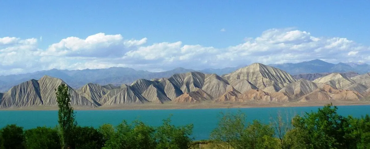
The reservoir flooded a valley in the 1970s to feed the Toktogul hydroelectric station, still the backbone of the national grid. It is engineering, not nature, but at this scale the distinction stops mattering: 65-odd kilometers of turquoise water ringed by dry, rust-colored mountains. Water levels swing dramatically between wet and dry years, so the shoreline you see may be a wide mudflat or lapping close to the road depending on when you pass.
The color is what catches people off guard. On a clear day the water goes a deep mineral blue-green that looks borrowed from a much more famous lake, and because the surrounding hills are bare and brown, the contrast is stark. Photographers should aim for morning or late afternoon; midday flattens the whole basin into haze.
The viewpoints worth a pull-over
Coming from Bishkek, the drama starts after the Ala-Bel pass and the long Chychkan gorge: the road spills out of the canyon and the whole basin opens up below in one wide reveal. The unmarked laybys on this descent give the best elevated panoramas, and any driver will stop if asked; theirs is a cigarette break, yours is the photo. Further on, the highway rides close to the southern shore with plenty of casual pull-offs. If you are self-driving, the stretch near the dam and the Kara-Kul side is impressive in a concrete-megaproject way, though photographing dam infrastructure is best done discreetly or not at all.
The white honey
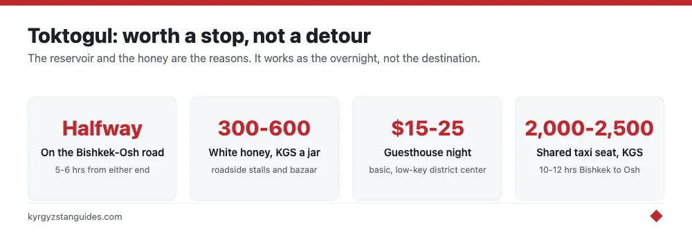
Toktogul’s real export is ak-bal, white honey made from sainfoin blossom, and it has a national reputation: creamy, pale, and mild in a way that converts people who find ordinary honey cloying. Roadside stalls and the Toktogul bazaar sell it by the jar for around 300-600 KGS depending on size and season, cheaper and fresher than the same jars in Bishkek supermarkets. Taste before buying; vendors expect it. A jar of it's one of the more genuinely local edible souvenirs in the country, up there with anything in our Kyrgyz food guide.
Breaking the journey
Toktogul town is the practical overnight: a low-key district center with several guesthouses and basic hotels in the $15-30 range, cafes serving lagman and shashlyk, and working ATMs. Shared taxis and marshrutkas between Bishkek and Osh all pass through, so splitting the drive here is easy to arrange. The alternative break is the Chychkan gorge just north, where a handful of roadside resorts and trout restaurants sit beside the river; prettier setting, fewer services. If your route has slack, the turnoff toward Sary-Chelek comes not far south, and that lake is a destination.
Getting there and timing the drive
No special planning is needed; the reservoir is simply kilometer marker scenery on the M41. Shared taxis Bishkek-Osh run around 2,000-2,500 KGS per seat and take 10-12 hours, passing Toktogul roughly at the halfway mark, five to six hours out of Bishkek. If you're in a shared taxi, negotiate photo stops when you board, not on the fly. Self-drivers have it best: the road surface is decent by Kyrgyz standards, and the two high passes before the basin, Too-Ashuu and Ala-Bel, are their own spectacle. Time your drive so you cross the passes and hit the reservoir in daylight; this road at night is all truck headlights and no scenery, and the mountain sections demand alertness.
One seasonal note: the passes see snow from roughly October to May, and chains or good tires matter at the edges of that window. In deep winter the reservoir scenery turns steel-gray and the honey stalls thin out, which removes most of the reasons to stop at all.
Can you swim?
Yes, in summer, and locals do; July and August water is pleasantly warm by mountain-lake standards. The honest caveats: access points are informal, the shore is stony or muddy rather than sandy, shade is nonexistent, and facilities amount to whatever you brought. A swim here is a refreshing 20-minute leg-stretch on a hot transit day, not a beach afternoon. Issyk-Kul it isn't.
Our verdict
Worth a stop, not a detour. If Toktogul lies on your road, plan an unhurried hour of viewpoints, buy the honey, and consider the town for the night rather than pushing a 12-hour drive into darkness on mountain roads. If it does not lie on your road, nothing here justifies creating one; spend that day at a lake that earns it. As a milestone that breaks the country’s greatest road trip in half, though, it does its job with some style.
The numbers behind the water you are driving past
The dam is a 215-metre concrete gravity structure on the Naryn, holding a reservoir with a total capacity of 19.5 cubic kilometres. Construction began in 1960; the plant came online in 1975 and was commissioned in stages through 1977.
It was built with four 300 MW Francis turbines for 1,200 MW. A five-year rehabilitation completed in 2025 lifted that to 1,440 MW, four units of 360 MW, adding about 6% to national generating capacity, enough for roughly 200,000 households.
The share that matters: Toktogul supplies around 40% of Kyrgyzstan's electricity. It also regulates the whole Naryn cascade below it, Kurpsai, Tash-Kumyr, Shamaldysai and Uch-Kurgan, so its release schedule sets the output of every plant downstream. When people in Bishkek talk about the lights, they are talking about this reservoir.
Why the level is a national anxiety
Below roughly 5.5 to 6.5 billion cubic metres there is not enough head to turn the turbines. That is the dead level, and the country has been uncomfortably close to it more than once. The reported figures tell the story plainly:
2 February 2022: 8.995 bn m³, down 2.925 billion in three months. 6 March 2024: 7.7 bn m³ against a normal 17.3. At that point the deputy energy minister said another 2 billion would take the reservoir to dead water, with daily consumption up to 70 million kWh against a normal 54 million. 1 January 2026: 9.14 bn m³. 1 April 2026: 7.0 bn m³. 7 September 2026: 51% of capacity.
The structural problem fits in one pair of numbers. On 27 December 2024 the reservoir was releasing 797 m³/s while only 183 m³/s flowed in. Winter is when the country needs power and when the rivers are lowest, so the reservoir is drawn down exactly when it cannot refill. In 2025 Kyrgyzstan generated about 15 billion kWh against demand of over 19 billion, and imported the difference.
The treaty that makes the water political
Upstream Kyrgyzstan wants to release water in winter to make electricity. Downstream Uzbekistan and Kazakhstan want it in summer to irrigate cotton and wheat. Those are incompatible, and the arrangement that manages the conflict is the Agreement on the Use of Water and Energy Resources of the Syrdarya River Basin, signed in Bishkek on 17 March 1998 by Kazakhstan, Kyrgyzstan and Uzbekistan, with Tajikistan added by protocol the following year.
Its Article 4 is the deal in one sentence: surplus summer hydropower goes downstream, and Kyrgyzstan is compensated, in coal, gas, fuel oil, electricity, other goods or cash, for holding irrigation water through the winter instead of burning it for power. It is a barter, and it is the Soviet arrangement rebuilt as a treaty between sovereign states.
It is still being renegotiated annually. A trilateral protocol signed in Tashkent on 7 May 2026 set release volumes and schedules for the season, and between September 2025 and April 2026 Kazakhstan supplied Kyrgyzstan with over 1.5 billion kWh specifically so that Kyrgyzstan could cut winter releases and hold the level up. The blue sheet you are driving past is the physical form of a regional negotiation.
The valley underneath
On 6 September 1973 the bypass channel was closed and the Ketmen-Tyube valley began to fill. It drowned the district centre of Toktogul and 22 villages. Estimates of how many people were moved range from more than 20,000 to about 35,000, and none of the figures in circulation come from an official source, so treat the scale as indicative.
The town you drive through was rebuilt on a new site north of the reservoir. It held 20,852 people at the 2022 census, up from around 16,000 through the 1990s and 2000s. Kara-Kul, the purpose-built town for the power plant, had 23,048.
Worth holding onto as you look at the view: this is not a lake. It is a valley with a town at the bottom of it.
FAQ
How big is the Toktogul reservoir?
Total capacity is 19.5 cubic kilometres, held back by a 215-metre concrete gravity dam on the Naryn river. Published figures for surface area and depth vary widely between secondary sources, so treat those with caution.
How much of Kyrgyzstan's electricity comes from Toktogul?
About 40%. The plant runs at 1,440 MW since a rehabilitation completed in 2025, up from the original 1,200 MW, and it also regulates the four Naryn cascade plants downstream.
Can you swim in the Toktogul reservoir?
In practice yes, and locals do in July and August. No official rule permitting or banning it could be found either way. Access points are informal, there is no supervision and no facilities, so treat it as a leg-stretch on a transit day rather than a beach.
Why does the Toktogul water level keep making the news?
Below roughly 5.5 to 6.5 billion cubic metres the turbines cannot run. It reached 7.7 bn m³ in March 2024 against a normal 17.3, and 7.0 bn m³ on 1 April 2026. Winter draws the reservoir down exactly when the rivers are lowest.
Was a town flooded to make the Toktogul reservoir?
Yes. The bypass channel was closed on 6 September 1973 and the Ketmen-Tyube valley filled, submerging the district centre of Toktogul and 22 villages. Displacement estimates run from over 20,000 to about 35,000 people, none from an official source.
How long is the drive past Toktogul on the Bishkek-Osh road?
You will skirt the water for well over an hour, roughly halfway through the 12-hour Bishkek to Osh drive. The best viewpoints are on the descent from the passes, with plenty of informal pull-offs.