The hardest part of the Kegeti waterfall hike isn't the trail. It's the last 20 kilometers of road, because no marshrutka goes anywhere near the trailhead, and that single fact shapes how everyone actually does this trip. Solve the transport, and Kegeti gorge gives you one of the best easy mountain days within reach of Bishkek: a proper waterfall, Tien Shan spruce forest, and an optional extension to Kol-Tor, a genuinely turquoise alpine lake.
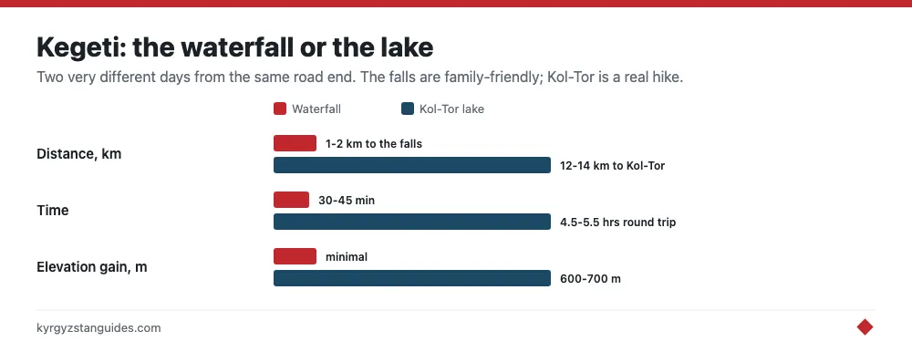
The essentials up front: Kegeti gorge sits about 90 kilometers southeast of Bishkek in the Kyrgyz Ala-Too. The waterfall is a short walk of roughly 1-2 kilometers from the road end, the Kol-Tor lake extension is a half-day hike of around 12-14 kilometers round trip with roughly 600-700 meters of climbing, and the only practical transport is a hired car or taxi for the day, typically 3,500-5,000 KGS from Bishkek including waiting time.
The transport problem, solved honestly
Public transport gets you to Kegeti village and no further. Marshrutkas run there from Bishkek’s eastern bus station, but the village sits at the mouth of the gorge, a long, dusty 15-20 kilometers below the waterfall trailhead. There is no onward service, and traffic up the valley is thin enough that hitching is a gamble rather than a plan. We have seen travelers burn their entire hiking day this way.
The realistic options, in order of sanity: hire a taxi or a Yandex Go driver from Bishkek for the whole day and agree the price up front; join a scheduled group day trip, which several Bishkek hostels and tour operators run in summer for around 2,000-3,000 KGS per seat; or self-drive a rented car with decent clearance. The valley road is unpaved past the village, rough but passable for careful sedans in dry weather. Our getting around Kyrgyzstan guide covers the taxi-negotiation basics that apply here.
The waterfall trail
From the parking area at the road end, the waterfall path climbs gently through spruce and juniper alongside the Kegeti river. It's short, obvious, and family-friendly: most people reach the falls in 30-45 minutes. The waterfall itself drops around 20 meters off a dark rock lip, and in June and early July, when snowmelt is at full volume, it's loud enough to end conversations. By September it thins to something more elegant than powerful.
Spray reaches the viewing area in high flow, and the final rocky steps get slick, so shoes with real tread beat sneakers. Weekday mornings you may have the falls to yourself; summer Sundays bring a steady line of Bishkek picnickers, which has its own cheerful charm.
The drive up the valley is part of the product. Kegeti gorge is greener and more pastoral than the better-known gorges west of Bishkek, with shepherd camps, beehive trailers, and the occasional yurt selling kymyz in season. Expect to be waved at, and expect the odd cow to contest the road. If a herder asks a small pasture fee near the parking area, 50-100 KGS is normal; treat it as parking money, not a scam.
The Kol-Tor extension: the real prize
If you have legs and daylight, Kol-Tor is the better half of the day. The lake sits in a side valley at around 2,700 meters, and its color is the selling point: a milky glacial turquoise that looks color-graded even on a gray day. Count on 12-14 kilometers round trip from the road with roughly 600-700 meters of gain, which translates to 2.5-3.5 hours up and around 2 hours down for a reasonably fit hiker.
The trail follows the river drainage steadily upward through pasture and forest, with one sustained steep section before the lake basin. Navigation is straightforward in good weather; the path is worn and shepherd traffic keeps it obvious. Swimming is technically possible and thermally inadvisable. Bring lunch and give yourself an hour at the water; the basin has flat grassy spots made for it, and the color shifts noticeably as clouds move. As a fitness benchmark, if you handled the popular walks in Ala-Archa comfortably, Kol-Tor is well within range; it's also a fair warm-up before committing to something like Ala-Kul.
Doing both the waterfall and the lake in one day is realistic only with an early start from Bishkek and a driver who waits. If you must choose one, we would choose Kol-Tor and accept that the waterfall becomes a 40-minute bonus on the way out, flow permitting.
Combining Kegeti with Burana Tower
Here is the itinerary trick that makes the taxi money hurt less: the turnoff for Burana Tower at Tokmok sits close to the Bishkek-Kegeti route, so the 11th-century minaret and its field of balbal grave markers add only around an hour of driving to the day. Hike in the morning, climb the tower’s claustrophobic spiral staircase in the late afternoon light, and you have paired the Chüy valley’s best nature day with its best history stop. Drivers agree to the add-on readily; settle the combined price before leaving Bishkek.
When to hike Kegeti
Mid-May through early October is the workable window for the waterfall; June through September for Kol-Tor, which holds snow later and higher. July and August offer the most settled weather but also afternoon thunderstorm buildups, so start early regardless. Autumn is excellent: golden pasture, stable air, thin crowds. Winter turns the waterfall into a climbable ice pillar that local alpinists train on, which is spectacular to see but a different sport entirely.
Kegeti also makes a smart acclimatization or rest-day filler if you're basing in the capital between bigger objectives; it slots neatly into any Bishkek stay without repacking your bags.
Before you go: the checklist
- Arrange transport the day before; agree total price, waiting time, and the Burana add-on in advance.
- Leave Bishkek by 7:00-7:30 if you're attempting both the waterfall and Kol-Tor.
- Carry cash in small notes for the driver and any pasture-use fees; there is nothing to buy up the valley.
- Pack a rain shell and a warm layer even in August; the lake basin sits at 2,700 meters.
- Water: the river is silty; bring 2 liters per person or a filter.
- Download offline maps; there's little to no signal past Kegeti village.
The numbers, and the fee you should expect
Kegeti waterfall drops 20 metres at the entrance to the gorge, about a hundred metres off the road. The walk in is genuinely short: from the parking area it is roughly 200 metres with about 30 metres of ascent, around five minutes. Anyone telling you it is a hike is overselling it; the drive is the effort.
That drive is about 85 km from Bishkek, two and a quarter hours. Asphalt gives way to dirt once you are into the gorge.
There is a checkpoint on the way in that takes vehicle registration details and charges an environmental fee, reported at around 200 KGS per car as of 2024. That is separate from, and more official than, the informal pasture money a herder may ask for near the parking area. Have both in small notes and do not confuse one for the other.
Above the falls, Kegeti pass reaches 3,750 m and is impassable for ordinary vehicles. If someone offers to drive you over it toward Chong-Kemin in a sedan, decline.
On season: the road is open in the warm months, and the falls are also a winter destination frozen. The spring snowmelt window is when they carry the most water and make the most noise.
One thing not to claim, because it is not true: Kegeti gorge has no protected-area status. The checkpoint and environmental fee suggest one, but Chuy oblast's nature parks are Ala-Archa and Chon-Kemin, and neither covers this valley.
FAQ
How tall is Kegeti waterfall?
About 20 metres, at the entrance to the gorge roughly 100 metres from the road. The walk from the parking area is around 200 metres with 30 metres of ascent — about five minutes.
How far is Kegeti waterfall from Bishkek?
About 85 km, or two and a quarter hours by car. The road is asphalt until the gorge, then dirt, passable for a careful sedan in dry weather.
Is there an entry fee for Kegeti?
Yes. A checkpoint records vehicle details and charges an environmental fee reported at around 200 KGS per car as of 2024. A herder may separately ask for small pasture money near the parking area — that is a different thing.
How high is the Kegeti pass?
3,750 metres, and impassable for ordinary vehicles. Do not let anyone talk you into crossing it toward Chong-Kemin in a rented sedan.
Can you visit Kegeti in winter?
Yes, and the frozen falls are a draw in their own right. Road access depends on conditions. For maximum water and noise, go during the spring snowmelt instead.
Is Kegeti gorge a national park?
No. Chuy oblast's nature parks are Ala-Archa and Chon-Kemin; neither covers Kegeti. The checkpoint and environmental fee are not the same as protected-area status.
For a gorge with no facilities, no ticket and almost nobody in it, ninety minutes from the capital, see Shamsi — a former hunting concession turned snow leopard sanctuary.
Above the waterfall, the Kegeti pass crosses to Kochkor at 3,805 metres — and not, despite what you may read, to Chong-Kemin.