Saimaluu-Tash is a high mountain plateau in the Jalal-Abad region that holds an estimated 30,000 to 35,000 carved images spread over some 4,500 to 5,000 stones, most of them made between 2000 BCE and the early Iron Age. That makes it the largest known petroglyph field in Central Asia, and one of the largest anywhere in the world: a significance reflected in its place on UNESCO’s World Heritage Tentative List. It spreads across roughly 2,860 to 3,350 meters, is snowed in for most of the year, and gets a fraction of the visitors that similar sites in Europe or the Middle East receive, mostly because getting there is genuinely hard.
If you’re weighing whether it’s worth the effort: yes, for anyone with a serious interest in prehistoric art or willing to treat the journey itself as part of the trip. It is not a casual afternoon stop. Expect a full day of 4WD driving plus a multi-hour hike, a licensed guide, and a June-to-September window that can still close early if snow arrives ahead of schedule.
What’s actually carved into the rock
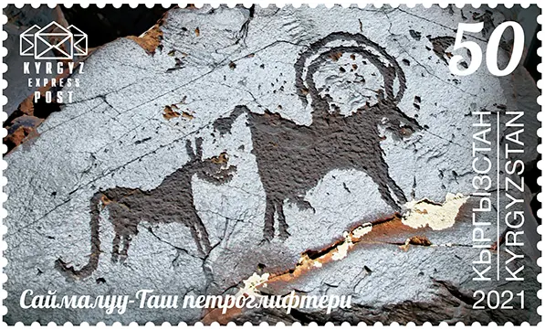
The carvings at Saimaluu-Tash span several thousand years of use, which is part of what makes the site significant. The oldest images, dated to the Bronze Age, show sun-headed deities, chariots, and ritual scenes that archaeologists connect to sun-worship practices among early pastoral communities in the Ferghana foothills. Later carvings, added over centuries by different groups passing through, layer in hunting scenes, herds of goats and ibex, and human figures in what look like dance or ceremonial poses.
What sets Saimaluu-Tash apart from smaller petroglyph sites elsewhere in Kyrgyzstan, like the roadside collection near Cholpon-Ata, is density and continuity. The carvings cluster across three main groups on the plateau, and walking between them gives a sense of a place that was returned to and reused across an enormous span of time, not a one-off ritual location.
Where it's and why the location matters
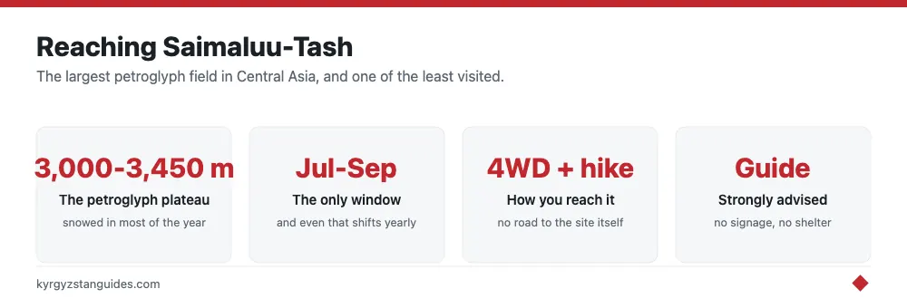
The site sits on the northern slopes of the Ferghana Range, in Jalal-Abad province, above the village of Kazarman. The plateau itself straddles roughly 3,000 to 3,450 meters, which explains both the thin, snow-free window for visiting and the near-total absence of infrastructure. There’s no visitor center, no signage system, and no accommodation on site. Whatever you bring in, you carry in.
Kazarman functions as the staging point. It’s a small town reachable by rough road from either Jalal-Abad or Naryn direction, and most trips to Saimaluu-Tash are organized from there rather than attempted independently from Bishkek in a single push.
Getting there: the part people underestimate
From Kazarman, reaching Saimaluu-Tash means a 4WD drive along a track that climbs through river valleys and switchbacks before the road effectively runs out, followed by a hike of several hours to reach the main carving clusters. Depending on where the vehicle track ends that season, walking time can run from two to five hours each way. This isn't a maintained trail with distance markers; route-finding on the plateau is part of why a local guide is close to mandatory rather than optional.
A permit is required to visit, arranged in advance through a guide or local operator in Kazarman, and travelers typically camp overnight near the site rather than attempting the round trip in a single day. Bring your own tent, sleeping bag, food, and water purification, since there’s nothing to buy once you leave town.
- Arrange a guide and permit in Kazarman, not in Bishkek
- Budget two to three days total, including the drive in and out
- Bring camping gear; there’s no shelter or supplies on the plateau
- Pack for near-freezing nights even in July and August
- Carry cash, there are no card facilities anywhere near the site
When to go
Saimaluu-Tash is only accessible from June through September, and even within that window, an early or late snowfall can shut things down. July and August offer the most reliable conditions and the longest daylight for the hike. Outside that stretch, the plateau is under snow and the access track is unusable, so there’s no realistic way to visit in spring, autumn, or winter.
This narrow season is one reason the site stays under most travelers’ radar: it simply isn’t an option for a large part of the year, and trip planning has to build around it rather than around personal preference.
Why it stays overlooked
Sites with comparable rock art elsewhere in the world, from Scandinavia to the Sahara, tend to have paved access, on-site interpretation, and organized tour circuits. Saimaluu-Tash has none of that, and the combination of altitude, distance, and a short season keeps annual visitor numbers low even by Kyrgyzstan’s standards. For travelers already building a trip around Jalal-Abad province or the walnut forests near Arslanbob, adding a few extra days for Saimaluu-Tash is a reasonable extension. For a first Kyrgyzstan trip built around Bishkek and Issyk-Kul, it’s a stretch goal rather than a must-do.
It fits naturally alongside other remote, guide-dependent destinations covered in our broader trekking guide, and travelers weighing the extra cost of a dedicated 4WD and guide should check current rates against the ranges in our travel budget breakdown. If you’re still deciding on transport logistics for the wider region, our guide to getting around Kyrgyzstan covers where 4WD hire and shared jeeps make sense versus public transport.
Planning checklist
Before committing to a Saimaluu-Tash trip, confirm four things: the season fits your travel window (June to September only, ideally July or August), you’ve booked a guide and permit through a Kazarman-based operator rather than trying to arrange access independently, your itinerary has slack for weather delays on the access track, and you’re physically ready for several hours of high-altitude hiking with a loaded pack. Cross-check dates with our best time to visit Kyrgyzstan guide if you’re combining this with lower-altitude stops on the same trip, since conditions at 3,000 meters and conditions in the Chüy valley rarely line up on the same calendar.
Why the published counts disagree so much
Look up Saimaluu-Tash and you'll be told it holds 10,000 images, or 12,000, or 90,000. The numbers aren't really in conflict — they are counting different things, and the confusion comes from collapsing two separate figures into one. The site is a boulder field. What gets counted is either the carved stones or the individual images on them, and a single basalt block can carry dozens of figures.
The most systematic modern survey is the 2017 expedition led by Christoph Baumer with Swiss and Belgian specialists, which mapped the field properly for the first time since the Soviet period. Its working figures are roughly 4,500–5,000 carved stones carrying 30,000–35,000 individual images. So the older "10,000 to 12,000" figure you'll see repeated is best read as a conservative count of images from an earlier, partial survey, not a ceiling. Either way the headline stands: this is the largest known petroglyph field in Central Asia.
The altitude gets flattened the same way. "About 3,000 metres" is the usual shorthand; the field actually spreads across roughly 2,860 to 3,350 metres, which matters when you're walking it, because the upper groups sit a genuine extra effort above the lower ones and clear of snow for less of the year.
Who found it, and the chronology they built
The site was brought to outside attention in 1902 by a topographer, Nikolai Khludov, working in the eastern Fergana range about 115 km northeast of Osh. Serious documentation came later and in two pushes: B. M. Zima in 1946 and A. N. Bernshtam in 1950, whose Soviet-era recording still underpins much of what's published. The 2017 survey revisited their conclusions with modern mapping.
The chronology those surveys produced runs longer than most visitors expect. The bulk of the carving is Bronze Age, roughly 2400–900 BC — the ploughing scenes with mixed draught animals and the battle chariots with spoked wheels belong here, and they are the images the site is known for. Carving continues through the Iron Age (900 BC–AD 450) and the Turkic period (c. AD 450–800), then stops around AD 800 and never resumes. Alongside the chariots you'll find deer, ibex, horses, wolves, snow leopards, solar symbols and hybrid creatures that do not map onto any living animal.
The thing that has protected all of it's the climate. The field is under snow for 10 to 11 months of the year, and reaching it means a glacier crossing. Vandalism and casual visitor wear — the standard fate of accessible rock art — have largely passed Saimaluu-Tash by, and the stone surfaces are in unusually good condition as a result. The difficulty that frustrates you is the reason there's anything left to see.
FAQ
How many petroglyphs are at Saimaluu-Tash?
Roughly 4,500–5,000 carved stones carrying an estimated 30,000–35,000 individual images, according to the 2017 Baumer survey. Older sources cite 10,000–12,000, which counts images from an earlier partial survey rather than the full field.
How old are the Saimaluu-Tash carvings?
The earliest and most extensive are Bronze Age, around 2400–900 BC. Carving continued through the Iron Age and the Turkic period and stopped around AD 800. Nothing was added after that.
What altitude is Saimaluu-Tash?
The field spreads from about 2,860 to 3,350 metres in the eastern Fergana range, around 115 km northeast of Osh. The commonly quoted "3,000 m" is the middle of that range, not the top.
When can you visit Saimaluu-Tash?
Realistically July to early September. The site is under snow 10–11 months of the year and the approach involves a glacier crossing, so the window is short and can close early if snow comes in ahead of schedule.
Is Saimaluu-Tash a UNESCO World Heritage Site?
Not yet. It sits on the UNESCO World Heritage Tentative List, which is the formal step before nomination. Inscription would require a full nomination dossier and committee decision.
Do you need a guide for Saimaluu-Tash?
Yes, in practice. There is no marked trail, the approach crosses a glacier, and the upper groups of stones are hard to locate without someone who knows the field. Arrange it in Kazarman or Jalal-Abad rather than turning up and improvising.