Start with the warning, because it frames everything else: on the treks below, nobody is coming to get you. Kyrgyzstan has no national mountain rescue service, helicopter evacuation is a private arrangement that takes days to organize if it happens at all, and on several of these routes you can walk for 48 hours without meeting another human. Difficulty here isn't measured in distance or elevation gain — it is measured in consequence.
For experienced hikers asking which routes actually deserve their reputation, our shortlist is: Ala-Kul when the weather turns, the remote approaches to Kel-Suu, the full Heights of Alay circuit, the Boz-Uchuk-to-Jyrgalan traverses, and the acclimatization routes above Lenin Peak base camp. All are achievable by strong, self-sufficient parties without ropes in high summer. All will punish complacency.
What “hard” actually means in Kyrgyzstan
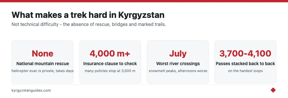
Alpine-country veterans arriving from Europe or the US need to recalibrate. In the Alps, a hard trail is steep but marked, mapped, and an SOS call away from help. Here, the trail is a braid of livestock paths that appear and vanish; the “bridge” on the map may be two wet logs or may have washed away in June; and the weather forecast for a 3,900-meter pass is an educated guess. The recurring objective hazards are unbridged river crossings (highest in July snowmelt, always worse in the afternoon), sudden whiteouts on passes, scree and moraine with no stable line, and altitude — most of these routes live between 3,000 and 4,300 meters.
The subjective hazards matter just as much: no signage means constant navigation decisions, no huts means full loads, and no rescue means conservative margins are the only margins. A party on these routes should carry a satellite communicator, a real paper-map-and-compass backup to the GPS, and the humility to turn around. Insurance that covers trekking above 4,000 meters is non-negotiable; read the altitude clause, because many policies quietly stop at 3,000.
Ala-Kul in bad weather: the famous one, with teeth
On a blue-sky August day, the Ala-Kul trek is a busy, moderately hard classic. We include it here because of what it becomes when the weather breaks — and above Karakol, it breaks fast. The 3,860-meter pass funnels wind, holds snow into July, and has genuinely loose, steep scree on the Altyn-Arashan side where a slip carries real consequences in ice or rain. Every season, trekkers summit the pass in a whiteout because their itinerary said so, and every season some of them are lucky rather than good. The competent move is boring: build a spare day into the plan, sit out storms at the lake camps or Sirota hut area, and cross the pass before noon when conditions are most stable. Treat shoulder-season attempts (June, late September) as snow routes and carry microspikes.
Kel-Suu: remote approaches near the Chinese border
Most visitors see Kel-Suu the easy way — a long 4WD ride from Naryn, a yurt camp, and a two-hour walk to the lake. The hard version is everything beyond that: multi-day approaches through the Kok-Kiya valley and surrounding ridges in a border zone that requires a permit arranged one to several weeks ahead. This is some of the emptiest terrain in the country, a high, treeless karst landscape above 3,500 meters where the nearest road is a day away and the nearest hospital far beyond that. Water sources disappear into the limestone, so carrying capacity and planning around known springs matters in a way it rarely does elsewhere in Kyrgyzstan. Weather comes off the Torugart plateau with nothing to slow it down. Parties here should be fully autonomous: no yurt camps off the main track, no phone signal, no passersby.
Heights of Alay: the full loop
The Heights of Alay circuit out of Osh, typically 6-8 days linking the Kojo-Kelen area, Jiptik pass, and the Alay valley rim, is our pick for the most sustained trek on this list. Nothing on it is technical in dry conditions, but the loop stacks difficulty relentlessly: three or four passes between roughly 3,700 and 4,200 meters on consecutive days, long scree descents, river crossings that swell by afternoon, and camps that rarely drop below 3,000 meters, so recovery never quite happens. Resupply is a village shop’s worth of noodles at best; most parties carry the full week. The reward is the Pamir-Alay at its most theatrical, red canyons, turquoise lakes, and the white wall of the Trans-Alay on the horizon, with a fraction of Ala-Kul’s foot traffic. Go with genuine acclimatization already banked, or spend the first days miserable.
Boz-Uchuk to Jyrgalan: link-ups without a script
East of Karakol, the Boz-Uchuk lakes and the valleys around Jyrgalan form a web of ridgelines and passes that can be linked into traverses of two to six days — Boz-Uchuk to Jyrgalan over the Ailampa or Anvar passes being the classic line. The difficulty isn't any single pass; it's that beyond the first valley the route becomes a navigation exercise. Trails fade into sheep tracks that contour convincingly in the wrong direction, GPS tracks from previous parties disagree with each other, and afternoon cloud regularly erases the ridgelines you were steering by. This is the list’s best test piece for map-and-compass competence: consequences are moderate, the terrain is honest, and bailout valleys exist if you can identify them. Parties that get casually lost here shouldn't attempt Kel-Suu’s backcountry.
Lenin Peak base camp and Travellers Pass
The walk to Lenin Peak base camp at Achik-Tash isn't hard. What earns a place here is the day-route network above it (Travellers Pass at roughly 4,100 meters and the moraine viewpoints toward Camp 1) because it is where trekkers most reliably meet real altitude. You sleep near 3,600 meters and walk to over 4,000 within a day or two of arriving from Osh at 1,000 meters; the arithmetic of acclimatization does not care how fit you are. The terrain adds glacier-margin hazards: crevassed ice starts abruptly past Camp 1, and the line between “trek” and “mountaineering” is a step wide. Go no farther than the pass without a rope team, watch for the headache-nausea-ataxia progression, and remember descent is the only treatment that always works.
The window: when these routes are actually in condition
The honest season for this tier is short: mid-July to early September, and even that comes with asterisks. Before mid-July, north-facing pass slopes hold consolidated snow, rivers run at their snowmelt maximum, and several Kel-Suu-area tracks are still mud. After early September, the first serious storms arrive with little warning and yurt camps, your only informal safety net, pack up and descend within days of each other. Mid-August is the sweet spot: rivers down, passes dry, camps still occupied.
Within any window, the daily rhythm matters more than the date. Weather at 4,000 meters here follows a pattern regulars learn to trust: calm, clear mornings; cloud building from noon; storms, wind, or graupel from mid-afternoon. Plan every pass for before midday, every river for before noon, and every camp to be up before the sky commits. Parties that treat 2 p.m. as the end of the decision-making day have far better trips than parties that treat it as the middle.
Honorable mentions
Three more routes sit just off the list. The Ak-Suu traverse east of Karakol — a high-level line linking the Altyn-Arashan, Taldy-Suu, and Boz-Uchuk drainages — offers days of continuous 3,000-meter-plus ridgewalking and would make the main list if its bailout options were worse. The backcountry ridges above Sary-Chelek in the west involve faint trails, thick forest navigation low down, and a resupply situation even thinner than the Alay’s. And winter ascents of otherwise moderate routes (Ala-Kul between November and April, most famously) convert familiar terrain into avalanche country that has killed experienced parties; that's ski-mountaineering territory, not trekking, and we treat it as out of scope here.
One more calibration point for anyone benchmarking against home mountains: none of these routes require ropes or climbing skill in season, which tempts strong hikers into treating them as long walks. The correct comparison is not a hard trail in the Alps or the Rockies; it is an unsupported route in Alaska or the Andean altiplano, where the party is the entire safety system. Judged that way, packing lists get heavier, daily distances get shorter, and trips get better.
Preparing for this tier
- Acclimatize deliberately: two or three nights above 2,500 meters (Karakol valleys, Song-Kul) before any 4,000-meter pass.
- Carry a satellite communicator and leave a route plan with your guesthouse and someone at home, with a fixed check-in schedule.
- Time river crossings for morning; snowmelt can double flows by 4 p.m.
- Bring microspikes for early or late season, and treat every forecast beyond 48 hours as fiction.
- Hire a local horseman-guide for routes you cannot confidently navigate. Around $30-50 a day, and their weather judgment is worth more than the load carrying.
- Check the altitude ceiling and trekking clauses on your insurance before, not after.
Our verdict
Ranked for overall seriousness, we would order them: Kel-Suu’s backcountry first for sheer remoteness, Heights of Alay second for sustained altitude, the Jyrgalan link-ups third for navigation, Lenin’s day routes fourth for altitude risk in a compressed timeframe, and Ala-Kul last: hard only when the sky decides it's. If you are choosing just one and want difficulty with a safety net, take the Alay loop with a local guide. And if the forecast is ugly, remember the only rule that matters in unrescued mountains: the pass will still be there next year, provided you are.
FAQ
What is the hardest trek in Kyrgyzstan?
The shortlist that genuinely deserves its reputation: Ala-Kul when the weather turns, the remote approaches to Kel-Suu, the full Heights of Alay circuit, the Boz-Uchuk to Jyrgalan traverses, and the acclimatisation routes around Pik Lenin. Which is hardest depends on conditions more than on any fixed ranking.
Is there mountain rescue in Kyrgyzstan?
No national service. Helicopter evacuation is a private arrangement that takes days to organise if it happens at all. On several of these routes you can walk for 48 hours without meeting another person.
How is difficulty measured on Kyrgyz treks?
Not in distance or elevation gain, but in consequence. The same logic governs the alpine routes above Ala-Archa. A route of modest statistics can be the serious one if a mistake on it cannot be undone and nobody is coming.
Do I need a guide for the hard treks?
For these routes, the absence of rescue is the argument for one. A guide is not there to carry your bag; they are the thing standing between a bad decision and an unrecoverable situation in terrain where outside help is days away.
What insurance do I need?
Cover that explicitly includes trekking at the altitudes you will reach and, crucially, evacuation — because evacuation here is a private commercial arrangement rather than a state service, and the cost falls on you or your insurer.
Can experienced hikers do these independently?
Some can, and do. The honest framing is that experience elsewhere does not transfer automatically, because what makes these routes hard is the absence of infrastructure rather than the technical ground.
If the crowds are the problem, the regional tourist board publishes seventeen quieter routes: see alternatives to the Ala-Kul trek.