Every spring the same scene plays out: travelers with early-June flights booked, asking operators to promise that the road to Song-Kul will be open. Nobody can promise, because in Kyrgyzstan nobody plows the high roads — the passes open when the snow decides to melt, and that date moves by two to four weeks from one year to the next.
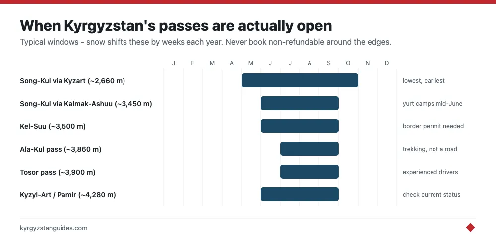
The rough rules, up front: jeep passes in the 3,000–3,500 meter band (Song-Kul’s main roads, Kel-Suu) typically open in early-to-mid June and close by late September or early October. Trekking passes near 4,000 meters, like Ala-Kul, are realistically July to mid-September. The lowest routes open in late May; the highest 4WD roads not until July. Below is the route-by-route detail, then how to check what's actually happening in the year you travel.
Why there are no fixed dates
Kyrgyzstan’s high roads are unpaved tracks over open passes, and no agency clears them for tourism. Opening day is set by snowpack and spring temperatures, which means a heavy winter followed by a cold May can hold everything back well into summer. There is also an awkward in-between phase: for a couple of weeks after the snow goes, the routes are rivers of mud, the fords run high with meltwater, and yurt camps haven't yet moved up. “Technically passable” and “worth doing” can be two or three weeks apart.
| Route / pass | Approx. elevation | Typically open | Notes |
|---|---|---|---|
| Song-Kul via Kyzart (west) | ~2,660 m | Late May – October | Lowest and earliest route in |
| Song-Kul via Kalmak-Ashuu (north) | ~3,450 m | Early June – late Sept | The main jeep road |
| Song-Kul via Moldo-Ashuu (south) | ~3,110 m | June – September | Famous 33-switchback descent |
| Ala-Kul pass (trekking) | ~3,860 m | July – mid-September | Snow lingers into early July |
| Kel-Suu road | ~3,500 m | Mid-June – September | Border permit required |
| Barskoon & Juuku passes | ~3,600–3,800 m | June – September | 4WD, south shore to Arabel plateau |
| Tosor pass | ~3,890 m | July – September | Rough 4WD shortcut to Naryn side |
| Kyzyl-Art (Tajik border) | ~4,280 m | Roughly May – October | Pamir Highway crossing |
The Song-Kul roads
Three main routes climb to Song-Kul, and they don't open together. The western approach over the Kyzart pass is the lowest and usually drivable by late May in an average year. The northern Kalmak-Ashuu road — the one most tours use — follows in early June, and the southern Moldo-Ashuu switchbacks around the same time. The more useful date, though, is mid-June: that's when the yurt camps set up and the lake becomes somewhere to stay rather than just somewhere to reach. At the other end, camps pack up in mid-September and the first serious snow typically shuts the high roads within a few weeks.
Ala-Kul pass
Ala-Kul is a trekking pass, not a road, and at roughly 3,860 meters it holds snow stubbornly. The dependable window for the Karakol-side crossing is July through mid-September. Strong hikers do cross in the second half of June in lighter snow years, but that version involves steep snow slopes and route-finding, and it isn't the trip the summer photos advertise. Coming over from the Altyn-Arashan side changes nothing about the timing — the pass is the pass. By late September the crossing is a mountaineering objective again.
Kel-Suu
The road to Kel-Suu, hard against the Chinese border in Naryn province, generally becomes passable in mid-June and stays open through September. Two extra wrinkles: the lake itself can still be partly frozen in June — it sits around 3,500 meters — and the area requires a border-zone permit that takes several days to arrange, so the paperwork, not just the snow, sets your earliest possible date. The classic month here is August, when the water is at its photogenic best and the yurt camps near the lake are running.
Barskoon, Juuku, and Tosor
The three high roads linking Issyk-Kul’s south shore to the Arabel plateau and the Naryn side are proper 4WD country. The Barskoon pass road benefits from mine traffic keeping its lower reaches in shape, but the high sections and the neighboring Juuku route are still June-to-September propositions. Tosor, the roughest of the three at nearly 3,900 meters, is best treated as July through September and only with a driver who has done it recently. These roads are spectacular — glaciers, red gorges, alpine tundra — and they're also exactly where you don't want to discover a late snowfield alone.
The Pamir crossing and other borders
Heading south from Osh toward Tajikistan, the Kyzyl-Art pass at about 4,280 meters is the highest crossing most travelers will ever drive. The Pamir Highway is officially open year-round, but for ordinary travelers the realistic window is May through October — outside that, weather closures and brutal conditions make timing a lottery, and you also need Tajikistan’s GBAO permit sorted in advance. The Torugart and Irkeshtam crossings into China operate through the year on paper, with weather delays in winter and a strict weekday schedule at Torugart. For lower crossings and the practical mechanics of reaching all these trailheads, see our guide to getting around Kyrgyzstan.
How much do dates shift year to year?
More than most planning resources admit. After a light winter with a warm May, the Kalmak-Ashuu road has opened in the last days of May; after a heavy one, tours have been canceling Song-Kul into the third week of June. Two to four weeks of swing is normal, and the higher the pass, the bigger the variance. This is why we give ranges, not dates — and why any itinerary in the first half of June needs a built-in plan B at lower altitude.
How to check current status
- Message guesthouses in Kochkor, Naryn, or Karakol a week out — hosts know which drivers got through yesterday, which beats any website.
- Ask the CBT (Community Based Tourism) offices in the towns nearest your route; arranging a driver through them doubles as a status check.
- Scan recent traveler reports on the Caravanistan forum and in Kyrgyzstan travel groups on Facebook and Telegram.
- Check iOverlander for dated check-ins on the specific road, especially for Tosor, Barskoon, and Kel-Suu.
- Treat any tour operator’s “guaranteed open” in early June with polite skepticism — ask when their last vehicle actually crossed.
Frequently asked questions
Can you reach Song-Kul in May?
Usually not, and even when a warm year opens the Kyzart route in late May, the yurt camps are not up and the lakeshore is cold mud. Mid-June is the earliest date worth planning around; late June is safer.
What is the earliest month for the Ala-Kul trek?
July, for a normal hiking experience. Fit, equipped trekkers cross in late June some years, but expect steep snow on the pass and bring traction. If your trip is in June, plan a lower-valley route and keep Ala-Kul as a bonus, not the centerpiece.
Can passes close again in mid-summer?
Briefly, yes. A cold front can drop snow on anything above 3,500 meters even in August. These closures typically last hours to a day — the snow melts fast in summer sun — but they're a good argument for buffer days on remote routes.
Do any high roads stay open in winter?
The main Bishkek–Osh highway stays open year-round via the Too-Ashuu tunnel, which bypasses the worst of its pass. The tourist jeep routes — Song-Kul, Kel-Suu, Tosor and company — all close with the first heavy snows and stay shut until the melt.
Do you need a 4WD for these roads?
For Song-Kul in dry mid-summer, a capable 2WD with clearance can manage the main roads, though locals still favor 4WD. For Barskoon, Juuku, Tosor, and Kel-Suu, treat 4WD — and ideally a local driver — as mandatory. River fords and washouts, not steepness, are what strand vehicles.